Thursday 13 April 2017

The Magnificent Temples of Ayutthaya

The ancient city of Ayutthaya in Thailand carries the legacy of Ayodhaya (India), the kingdom of Lord Rama, the hero of the Hindu epic Ramayana. Ayutthaya is known for some of the most beautiful and evocative Buddhist temples in the world.


Ramayana in Thailand

Hindu epic Ramayana had a profound impact in East Asia, from Myanmar and Thailand to Indonesia and Vietnam. Even in China, the stories of Sun Wukong seem to be inspired by Hanuman in Ramayana.

The two Indic religions, Hinduism and Buddhism, travelled from India to ancient Siam (Thailand). The influence of Hinduism was earlier, leading to the popularity of Ramayana. Thus the kings of Siam took the name of Lord Rama, considered to be an Avatar of God Vishnu. Rama's kingdom was in Ayodhaya and thus, the capital of Siam kings was also named Ayotthaya.

Thailand shows the combined influence of Buddhism and Hinduism, where the two Indic religions have blurred boundaries. Many traces of this ancient Hindu influence are visible in the Buddhist temples of Ayotthaya today, like the statue of the God Ganesha at a small shrine in the Wat Phra Si Sanphet temple below.


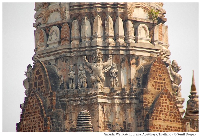
Apart from the names of the capital city and the king, many traces of Ramayana continue to be strong, including the representation of Ramakien (Ramayana) in the different art forms of Thailand. The image below shows the statue of Garuda, another character from Ramayana, from the Wat Ratchaburana temple in Ayutthaya.


Brief History of Ayutthaya

Ayutthaya, located in the valley of the river Chao Pharaya, was the old capital of Siam (Thailand) till about 150 years ago. The city was founded in 14th century on a river island. The Autthaya kingdom had different wars with the Burmese kingdom. After one such war in the 18th century, the city was destroyed.

Visiting Ayutthaya

I was in Thailand for work and had only a few hours free to be a tourist. I decided to visit Ayutthaya, even if I knew that I will have little time to visit it properly.

I took an early morning mini-bus from the North Bus Stand in Bangkok and the journey took around an hour and a half. I only had about 2 hours for my sight-seeing in Ayutthaya. I decided to focus on visiting a few Buddhist temples in the area along the Muang river as it goes and joins Chao Pharaya river.

I had got down from the mini-bus near Chao Phrom market. There were elephant-tours to visit the city but I didn't have the time for a leisurely elephant tour. So, from the market I walked to the Uthong road, near the Muang river, where I rented a bicycle.

With a map of the old town in my hand, I started on my bicycle towards Wat Maha That temple. "Wat" means a Buddhist temple. Wat architecture includes spires (Prangs), Stupas (Chedi) containing sacred relics, and statues of Buddha and Bodhisattvas.

Suddenly on the right side of the road, I saw the ruins of an old Wat, which was not shown on the tourist map. It had a tall chedi and the broken head of big Buddha statue in front of it. I thought that it was very beautiful.


Wat Maha That

Wat Maha That is located to the east of the Grand Palace. At one time it was the royal temple. Buddha relics were enshrined in the main Chedi of this temple. The supreme patriarch of the Buddhist monks resided in this temple.


Its construction was started in the 14th century during the reign of king Phra Borommarachatthirat I but was completed 20 years later during the reign of Uthong king Ramesuan. Its main Pagoda had collapsed in early 17th century and was rebuilt some years later by king Prasat Thong.

The monastery and the temple were destroyed by the Burmese in the 18th century. Thus, almost all the Buddha and Bodhisattvas statues at Maha That temple are headless and broken in different parts.


Wat Thammikarat

After Maha That temple, I went towards Wat Thammikarat. This temple area includes different buildings, old ruins as well as, a working temple. Some parts of this temple pre-date the establishment of Ayutthaya city, when it was known as Wat Mukaraj.

One of the first buildings of this complex is a bell-shaped Chedi with an octagonal base. It has a row of 52 royal Singhas (lions) all around it.


Opposite the Chedi are the ruins of a Viharan (hall) called "Harn Song Dhamma" used by the monks for prayers. It has a Buddha statue and a shrine for prayers.


A distinct mark of this Viharan are statues of roosters, brought as offerings by the faithful. There is a legend of a cock-fight competition between a Burmese and a Thai prince associated with this Viharan. It seemed to be a very popular religious place for the Thai people, though I could not find someone who could speak English to explain its significance to me.


Finally behind the ruins is the still active Buddhist temple Wat Dhammikaraj which includes the golden statue of a monk. On one side of the Chedi, I saw a shrine with a blue coloured Buddha covered with yellow wrap, I thought that it was beautiful.

Wat Phra Si Sanphet

This was the most important temple of ayutthaya before its destruction in the 18th century by the Burmese. However, it did not start as a temple, rather it started as the first royal palace when Ayutthaya had become the capital in 1351. After about a hundred years, the royal palace was shifted to another building and this place was converted into a temple.


It was a royal temple and no monks lived here.


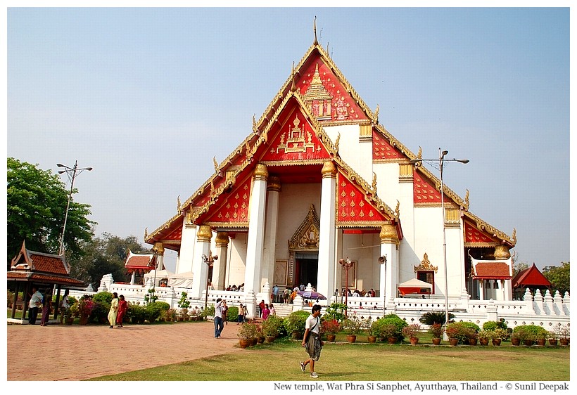
A 16 metres high Buddha statue covered with gold was installed in the Viharan of Wat Phra Si Sanphet in 1499. Most of the temple, except for some bell-shaped Chedis, was destroyed by the Burmese in the 18th century. Just across from Si Sanphet ruins, a new building hosts a new giant statue of Buddha today.


Conclusions

My visit to Ayutthaya was very brief. I could visit only a small part of the temple-ruins present in this beautiful town. The ruins of broken Buddha and Boddhisattva statues had a strong emotional impact on me.

The Burmese were also Buddhist, so why did they destroy the Buddhist temples of Ayutthaya? I don't know the answer to this question. Perhaps it was just for looting and not because they did not like the Thai religious ideas.

I wish one day to return to Ayutthaya and spend a few days there, going around the town, and soaking in its atmosphere of beauty coupled with destruction and timelessness.


If you like old ruins of Buddhist temples, visit Ayutthaya, it has wonderful atmosphere and the old ruins of the temples declared as world heritage by UNESCO are unforgettable.

***

Monday 10 April 2017

The Dancing Gods of Thayyem

"Theyyam" is a religious folk dance from the south of India. It is characterised by intricate make-up and beautiful costumes in striking colours with a predominance of orange, red and yellow. A visual kaleidoscope with a profound spiritual connection makes Theyyam a unique experience.


Spiritual Background and Meanings of Theyyam

Hinduism is based on the idea of all pervading universal consciousness known as Brahman, which has no beginning or end. Thus, mountains, trees, animals, birds and humans, everything animate or inanimate are the expression of Brahman and indicate a unity of all life forms.

In Hinduism, this idea of Brahman is coupled with Gods, one deity for each of the millions of life forms. In Theyyam, the dancer asks a God to come and become manifest in his body. Thus, during the dance-ritual, the dancer becomes an expression of God.

In other parts of India, there are persons who can go into trance and become "a channel of God" to speak and interact with people. For example, in north India they call it "Devi aayi hai" or the "Goddess has come". However, in Theyyam the invocation of God in human body is formalised and accompanied by specific costumes and rituals.


Theyyam Areas in Kerala

Theyyam is widespread in northern parts of Kerala state, especially around the town of Kannur. Each village and temple has its own Theyyam based a specific God or Goddess or local hero.

There are about 450 kinds of Theyyams. Each Theyyam has its own day during the year when its function will be organised in the village. Theyyam dancers are only men, usually from Hindu lower castes. Only one kind of Theyyam dancers are women.

Theyyam Preparation and Ritual

Around three weeks before the Theyyam celebration, the dancers start a period of abstinence to purify their bodies and minds. One day before Theyyam, they carry out a special invocation prayer called Thattam.

On the day of Theyyam, the dancer prepares his make-up using natural colours. During the make-up, their faces will carry complex designs for their specific Theyyam God and they will wear the ritual dress which is created and maintained by the dancer's family. The facial make-up for each Theyyam is also known as "Face-writing". The costumes include an elaborate head-dress and a breast-plate.

After completing the make-up and putting on the costume, the Theyyam dancer is shown his face in a mirror. This ritual is called Mukhadarshanam. It completes the arrival of God in his body. From that moment he ceases to be seen as human and becomes the manifestation of a specific God or Goddess.


During Theyyam, the specific story or the myth associated with that God is re-enacted. It takes place in front of a shrine, usually a sacred groove of trees. There is no stage and the dancer remains surrounded by believers. People play an active role in the enactment of the sacred story. They ask for the blessings of the God and sometimes ask questions to the Theyyam about their personal issues and problems.

Challenges Facing the Theyyam Traditions
Usually Theyyam dancers do it as a part of their family tradition and there is no or little income from it. With increasing modernisation, urbanisation and technology, it is becoming difficult for individuals to maintain complex social traditions like that of Theyyam, even if it has deep roots in the myths and cultures of the local societies.

Traditions like Theyyam are also under attack because some persons look at them as superstitions, or old fashioned backward rituals. They ignore its social roots and relevance, and look at it in isolation.

Theyyam plays a social role in the complex hierarchy of castes among Hindus. For example, in an interview, a Theyyam dancer said that though socially he belongs to a lower caste, when he becomes Theyyam, persons of all castes including Brahmins and upper caste persons must bend before him and ask for his blessing.


Over the past few years, government departments of culture and tourism are supporting to keep alive Theyyam, by including it as a part of cultural programmes and providing some income generation opportunities to the Theyyam dancers. Even if in such programmes, Theyyam is perceived only as an exotic visual experience, it provides an incentive for the dancers to valorise their skills and to continue the tradition in their own local communities.

Theyyam Face Make-up in Kochi Folk-lore Museum

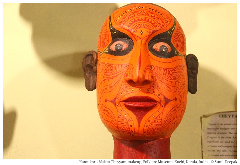
The Folk-lore Museum of Kochi has a collection of wooden heads illustrating the different "Face-Writing" designs made for different Gods and personas used in Theyyam. One of these is shown below.


Visiting Theyyam Dance in Kerala

Theyyam ritual dances are organised in villages in north Kerala during winter - especially between October to April. There is a weekly calendar of Theyyam events happening in different villages around the city of Kannur. You can find out it from different websites - here are two examples - TheyyamCalendar and KannurTravel.

Thus, if you want to observe a Theyyam ritual dance in its local village context, check the calendar and plan your visit to Kannur.

Conclusions

I have only seen Theyyam as a part of cultural programmes, as street art and as museum artifacts. I have used the images from those different encounters with Theyyam in this post. However, I hope one day to visit Kannur and see it as part of the local spiritual-religious tradition.


***

Saturday 8 April 2017

The Green Lake of Braies

The lake of Braies is a beautiful place in the South Tyrol region in the Alps mountains, in the north-east of Italy. A recent Italian TV series featuring Terrence Hill was shot here, which has made it famous.


I had been to Braies for a brief visit more than ten years ago. Since then I had promised myself to go back and visit it properly. Finally I had the opportunity to be there during the early summer. This post is about this magical lake which mirrors the deep green of the surrounding pine trees.

Braies and the Dolomite Mountains in South Tyrol

Tyrol region in the south of Austria and the north-east of Italy is known for its beautiful Alpine villages, emerald green highland pastures, lovely spotted cows with the tinkling bells around their necks, typical wooden houses bursting with flowers and the yoodling guys.

Till the first world war (1914-1918), South Tyrol was a part of Austria. As the Austrian-Hungarian empire lost the war, this part became a part of Italy. Thus, though it is in Italy, many persons here speak German.

The Braies lake is surrounded by the Dolomite mountains. These mountains are made of carbonate rock and are also called the Pale Mountains. With their craggy skylines, the Dolomite mountains make a very striking frame encircling this lake.


It is not a natural lake. It was formed by a landslide which blocked the Braies river. The deepest part of the lake are almost 40 metres deep. The lake's water looks green because of the pine tree forests at the lower slopes of the mountains surrounding it.

Reaching Braies

A local train or the suburban buses starting from Bressanone (Brixen) can take you to Braies town. Bressanone is on the main train line and along the highway connecting Trento (Italy) and Innsbruck (Austria).

We started our journey by car from Rio di Pusterla (Mühlbach), a small town a few kilometres north-west of Bressanone (Brixen).

The road going towards Braies, initially along the river Rivenza, was full of incredible panoramas. Often we passed Alpine villages with silken green meadows resting against the tall mountains in shades of blue, grey and green.


There were a number of small quaint looking churches with long bell-towers in most villages, inviting us to stop there and to taste the local cheese, wines and other specialities.


Braies lake (Pragser Wildsee)

Though we visited Braies in early June while the peak tourist season is in July-August, still it was crowded and we could only find a parking place some distance away.

The mountains around the lake are criss-crossed by high altitude hiking trails, some of which may take up to a week to complete. Simple hotels and dormitories called Refugio (Refuge) are built along these trails where people can stop and rest. Going on these trails requires proper equipment, practice and preparation. One of the most famous Alpine mountain trails called Alta Via 1 starts from the Braies lake.


However, we were not planning to do serious hiking. We took an easier pathway, which goes all around the lake. The complete walk around the lake requires about 2-3 hours and if you often stop for clicking pictures (like I do), you will need even more time. It has many ups and downs and therefore requires a modest resistance.


Among the other things to see near the lake, there is a historical hotel called Hotel Pragser Wildsee and a lakeside chapel called Marienkappel.


At the beginning of the left bank of the lake there is a wooden boat-house, where you can rent a boat.

Fame of Braies Lake

The first series of the Italian TV fiction "Un passo dal cielo" (A step from heaven) with Terrence Hill was shot here in 2010. In the first three seasons of this serial, Hill played a forest guard while the Braies boathouse was shown as his home. This serial was a big hit. Due to this serial, the Braies lake has become very popular among visitors.


Braies Lake in the Second World War

Towards the end of the Second World War, Braies lake was witness to an important historical event. In 1945, fearing the defeat, Hitler asked his SS troupes to take important persons kept as prisoners in the concentration camp of Dachau and to shift them to South Tyrol. The soldiers had the orders to kill all these prisoners before the arrival of Allied forces. However, the German Wahrmacht decided to protect these civilian prisoners, who were lodged at the Pragser Wildsee hotel and liberated by the allied forces.


Among those prisoners at Braies, there were many famous persons including, the former chancellor of Austria Kurt Von Schuschenigg, the former prime minister of France Leon Blum, the former prime minister of Hungary Miklos Kallay, the chief commander of Greek military Alexandros Papagos and many others.

The Legends of Braies Lake

There are stories of a legendary group of people called Fanes who are supposed to be hiding in the depths of Braies lake. On the night of full moon, the secret door to the hidden world of Fanes opens and the Fanes queen along with her daughter Dolasilla come out to walk on the surface of the Braies lake.


Another legend is about some wild persons who lived in the mountains around Braies and who had found gold in these mountains. Then shepherds and farmers from outside arrived here and started to steal their gold. Thus the wild persons of Braies blocked the river and created this lake so that outsiders could not reach them to steal their gold.

Ponticello of Braies

Apart from the lake, the areas surrounding Braies are famous for their beautiful panoramas. We visited one of these places - it is called Ponticello (Small Bridge).


The craggy skyline of the mountains as seen from Ponticello was very impressive.

However, on that day, the road for going up in the mountains of Ponticello was closed due to a landslide, so we could go higher up.

The old town of Braies was once known for the thermal baths containing sulphur. These are now closed. However, we did not visit it and promised ourselves to return to Braies to discover more of its surroundings.

Conclusions

Braies lake is famous for its beauty. We found that its fame is worthwhile. The clear Turkish-blue and green waters, the snow-covered majestic Dolomite mountains reflected in the lake and the beautiful pathway around the lake, make it a magical place. If you are visiting this part of Italy, do not forget to visit the Braies lake!


***

Wednesday 5 April 2017

The Rainbow Walls of Dozza

In a country where medieval towns with quaint castles are common, how do you make your town special? Simple, you dip the town in the colours of the rainbow! That is what happened in Dozza, a small medieval town about 30 km from Bologna in northern Italy - its walls are covered with paintings.


Origins of the Street Art in Dozza

With 6,000 mostly aging population, young ones leaving the town to go to Bologna, Dozza has been in a slow but obvious decline. The town decided to reinvent itself in the early 1960s. They decided that they will have a unique selling point for the tourists, by making their city a vast open-air art gallery.

Initially the local artists were asked to make paintings outside on the walls of the houses and the town started to become famous. People came to look at the houses with paintings. Now it holds a painting festival every two years in September. The next biannual painting festival is planned for September 2017.


Over the last few years, the wall-painting event of Dozza collaborates with the Museum of Modern Art in Bologna. Medieval Dozza is a tiny town, and as its walls get covered with art, some neighbouring areas such as the Borgo Nuovo of Toscanella are also being involved in this initiative.

Reaching Dozza

Bologna is an important node for road and railway network in north Italy. Reaching Dozza is easy. It is just 30 km away, so you can drive down. Suburban buses from Bologna going to Imola stop in Dozza. From Bologna you can also take a taxi. Or, you can take a train from Bologna to Castle San Pietro Terme or to Imola, and then take a taxi from there.

The Art in Dozza

Dozza is nestled at the top of a hill, and is dominated by a castle. The surrounding area has gently rolling hills covered with vineyards.

The medieval part of the town has ancient pebbled streets that go up and down all around the castle. It is a small area closed by the medieval walls, through which you can have glimpses of the beautiful surrounding hills, green meadows and valleys. Behind the castle there is a park on the side of the hill, full of steps going up and down.


Every street of the medieval town has houses covered with art by different artists. The result is a wonderful mix of styles and colours. Every corner has a surprise.


One of my favourite paintings in Dozza has a winter evening and a peasant family sitting around the dining table, with curtains around the window, a fire burning in corner, and a languid cat looking down at you curiously.


Another personal favourite has two persons painted in African style who are chatting, where the windows of the house become the ears of the two persons and part of an arch becomes the forearm of one of them.


Castle of Dozza

It has a lovely small castle at the top of a hill, belonging to the Marquis of Malvezzi-Campeggi family since 1500s. The last heir to the marquis family died in 1960 and the castle now belongs to the municipality.


It has a museum and in its basement, it hosts the regional wine centre where you can buy the local wines. The most popular local wine is San Giovese, but there are many more.


A famous restaurant, La Locanda del Castello, is on the hillside, not far from the castle of Dozza.

Conclusions

The medieval town with its pebbled streets, the small castle and the beautiful paintings, these all combine to make Dozza a special place. Thus, if you are planning a visit to Bologna, keep a morning for visiting Dozza, it is worth it.


***

Monday 3 April 2017

Rock Art of Bhimbethka

Bhimbethka is a place of great natural beauty. It has giant sandstone rocks, sculpted into hollows, crests, platforms and curls by the wind, rain and water. These are story-telling rocks, whispering their tales through the art of early humans. It is one of the most fascinating places that I have visited.

I had read about the rock-art of Bhimbethka about fifteen years ago and had immediately decided that one day I was going to visit this place. However, as often happens, life has its own compulsions and thus, I had almost forgotten about it.

A visit to the rock-art site in south-west Mozambique at Chinhampere a few years ago, had touched me deeply and had reminded me about my desire to visit Bhimbethka. Finally, a few months ago I visited it. If you are interested in human evolution and rock art of ancient humans, you will love Bhimbethka. It is located in Madhya Pradesh in the central part of India.

Rock-shelters of Bhimbetka are a World Heritage Monument of UNESCO.

DISCOVERY OF BHIMBETHKA

The rock shelters of Bhimbethka were discovered by V. S. Wakankar in 1957. Wakankar, while passing near Bhimbethka in train was struck by the curiously shaped rocks at the top of the hill and decided to stop and visit them.


This area is 600 metres above sea level and about 100 metres above the surrounding plains of Betwa river. Here the rock shelters used by prehistoric humans are scattered over a large area spread over five different hills – Bhineka, Bhonravli, Lakhajwar est, Lakhajwar west and Bhimbethka. All together there are 243 rock shelters, out of which 133 rock-shelters have rock-art. The whole area is part of Ratapani wildlife protected area.

Only 15 rock-shelters of Bhimbethka hill are open to public.

Bhimbethka is at one hour drive from Bhopal. You can hire a taxi to visit it. If you prefer public transport, state buses can drop you at about two and half kilometres from the caves.

EARLY HUMANS IN INDIA

In his wonderful book “Indica: A Deep Natural History of The Indian Subcontinent”, Pranay Lal writes that the progenitor of Anthropoids (monkeys, apes and hominins) developed in Asia and from there spread to Africa and other parts of the world. The first human progenitor Homo habilis evolved in Africa. The standing hominid, Homo erectus arrived about 2 million years ago and then over a short period of time spread into different parts of the world including India, China and Indonesia.

Standing posture of Homo erectus resulted in anatomical changes in pelvis which affected child-birth and children being born without fully developed brains, which created social needs for ancient humans to help each other and to live in communities. They learned to use fire, could make sounds for communication and made stone tools (Acheulean stone tools). Erectus arrived in India around 1.5 million years ago. Some of big sites of Acheulean tools of Erectus in India have been found around Siwalik hills.

The first modern man, Homo sapiens evolved in East Africa around 190,000 years ago. They left Africa around 75,000 years ago and spread in different directions including some who arrived in India. For some time, Erectus and Sapiens cohabited, then Erectus gradually faded away and only Sapiens remained. There were different sub-species of Sapiens including Neanderthals. The present day humans are Homo sapiens sapiens.

ANCIENT HUMANS IN BHIMBETHKA

The rocks of Bhimbethka are formed of sand-stone (orthoquartzite), which have been modelled by the natural forces into different shapes, which provided shelters to early humans. They are not caves and therefore called rock-shelters. Some of them are very big, more than 20 metres high.

Not very far from Bhimbethka is a tribal village, which shows the continuity of human traditions in this area.

The rock-shelters open to the tourists are located on a hill and are numbered from 1 to 15. The path between the different shelters has been paved and covers around one and half kilometres. The oldest signs of humans in these rock-shelters go back to around 100,000 years while the most recent signs belong to medieval period.

Archaeological excavations have been carried out in some areas of Bhimbetka that have shown tools, burials and other objects from lower Paleolithic, middle Paleolithic, upper Paleolithic, Mesolithic and Neolithic periods. The lower Paleolithic tools include Acheulean stone implements.


However, for the visitors to Bhimbethka, the most important signs of prehistorical humans are their paintings on the rocks made with natural elements like lime and ochre. Over the centuries, ancient humans have painted repeatedly at the same surfaces, thus more recent rock paintings overlie older paintings. In some places fifteen layers of paintings have been identified in Bhimbethka.

The paintings show mainly human and animal figures and depict scenes from hunting, wars, social and spiritual lives of persons. Trees, plants and flowers are rare in these paintings. Persons riding horses and elephants as well as battle scenes are part of more recent paintings from historical period.

THINGS TO LOOK FOR AT BHIMBETHKA

Personally, I found all the rock-shelters of Bhimbethka fascinating. There were some places where I could have spent hours looking carefully at individual paintings. However, there are some aspects that you can look for specifically during your visit:

Rock-shelter 2: It is an imposing structure shaped like an enormous cave open at the two ends and is known as the auditorium. It is 39 metres long and around 17 metres high.


On the left at lower level it has some more recent animal and human figures. To the right and on a higher level it has different animals and birds including a peacock and the hand impression of a child. It also has some cupules from early paleolithic period.


Rock-shelter 3: It has some curious round-shaped holes called Cupules cut into the rock. These are the oldest signs of human occupation in Bhimbethka and go back to 100,000 years. I think that these could have been used as storage spaces.


Rock-shelter 4: This shelter is called “the zoo” because its big wall is completely covered with different layers of animals painted during different epochs. There are 252 figures of animals showing 16 species of animals. In addition there are 90 human figures, 1 bird and 6 decorative designs.


Rock-shelter 5: More recent paintings in this shelter depict battles and a royal procession. These are located on the right side of the wall. The procession includes people carrying swords, riding horses and wearing a head-dress. The figures include two drummers.


Why did the ancient humans paint animal figures? One of the reasons proposed for these images found in different parts of the world, is related to hunting. Painting the animals (and conducting ceremonies in front of these figures) was a way to capture the spirits of the animals so that the hunters had success in hunting them.

Rock-shelter 15: This is a very big rock and on one side near the top, it presents a fascinating fantasy scene – a giant boar like animal is chasing a small human figure and a crab. It seems to be the depiction of a mythological story. Because of this painting, it is known as Boar rock.


Apart from the Boar scene, there are other human and animal paintings in this rock shelter.

View Point: Around half-way into the shelters, there is a raised area with a tortoise shaped rock. From here it is possible to see the alluvial plains around Betwa river going towards Narmada river.


In addition, there are three springs in this area known as Ban Ganga, Gupt Ganga and Pandapur. Water from these springs is used by the adivasi (tribal) groups living in this area. Finally at the top of Bhimbethka hill is an old Shiva temple nestled in the rocks.

CONCLUSIONS

Bhimbethka is an incredible place. Its natural beauty is coupled with a rich cultural, historical and archaeological testimony of the human evolution in central India.

At the rock-paintings of Chinhampere in Mozambique, I had met a woman guardian of the ancient site who lived in the village below. It was not possible to visit those rock-paintings without her permission. She had also explained to me about how the village community continued to venerate those rock paintings during their annual festivals.

This continuity of the sacred relationship between the ancient rock art and traditions of local tribal people seems to missing from the areas open for visits in Bhimbethka. Nor does the site provide any information about the religious/spiritual significance of these rock-shelters to the tribal communities today.

Still it is impossible not to be moved by the art of ancient humans at Bhimbethka. The name of Bhimbethka remembers the muscular Pandav brother Bhim from Mahabharat. Local legends say that Pandavas had lived here during the 12 years of exile.


Diane Ecke in her book “India – A sacred geography” has shown how different parts of India take the sacred stories of Hinduism, add to them their local heroes, gods and legends, and make them their own. The legends of Bhima and the names of the three springs, Ban Ganga, Gupt Ganga and Pandapur, seem to follow this norm.

My interest in ancient humans and their lives was stimulated by the series of books called Earth’s Children by Jean M. Auel in the 1980s and 1990s. If you have not read them, do read them. They will give you a glimpse of the lives of early humans.

I also recommend Pranay Lal’s new book – “Indica: A Deep Natural History of The Indian Subcontinent”. It is an enjoyable read, full of information about geological, archaeological and biological finds in India.

***

Popular Posts