Tuesday, 3 October 2017

Those magnificent men on their flying machines

Many men have a special relationship with their motorcycles. For a long time, I could not get why they felt that way. I had ridden on motorbikes in my younger days and while I had loved the thrill of speed with the wind rushing past, I had not got hooked to that sensation. It all changed around a decade ago.


This post is a photo-essay about motorbikes and the guys who love them.

Introduction

In Italy, I live in Schio, in the foothills of Alps. Schio has a strong motorbike loving community and the Schio moto-club is almost one century old. We have regular motorbike rallies, of the vintage bikes and, of moto-cross with sport-bikes. Most of the pictures with this post are from two recent local motorbike events (Schio-Pasubio vintage motoraduno and Off-road moto-cross).


In the final part of this post, I also have a few pictures of motorbikes from India and Brazil.

A word about the title of this post.  Those magnificent men in their flying machines, was the title of a 1965 British film. If you have never seen this film, do look for it and watch it, it is wonderful. The film was about airplanes but it also fits this post.


From motorbike hater to lover

At the age when many men love motorbikes, I was content to read "Zen and the art of motorcycle maintenance". I was convinced that riding a motorcycle was a surefire recipe for an accident. These ideas may have been linked to the death of a friend's brother in a motorcycle accident.

For a long time, I held on to those ideas. When my son became an adolescent and many boys of his age were going around on their motorbikes, I insisted that I would rather help him buy a used car than a motorcycle.

And then, after crossing fifty, when most men put away their bikes and opt for the safety of a car, I suddenly discovered my passion for motorcycles. I can't pinpoint the exact moment when it happened but suddenly I realized that I loved watching and dreaming about motorbikes.


Probably, horse-riding is similar to motorbike riding at some level? Like motorbikes, often cowboys have a special feeling for their horses. I am not sure what Freud would have to say about this, but I am sure that you can guess it!

My passion for motorbikes started with vintage bikes. I remember coming across an exhibition of vintage bikes some 7-8 years ago, and I was completely taken by them. Since then, whenever there is a rally of vintage motorcycles, I go there to look at and admire the old models of bikes.

There was a time when there were just two kinds of motorbikes - the ones for normal roads and the ones for rocky terrains and track-roads. Today there is a larger differentiation in the kinds of bikes such as custom-made, cruisers, choppers, rat bikes, bobbers, sport, naked, trike and sidecar. I am not sure about the differences between most of them.


The motocross bikes are lighter and have robust suspensions. Usually they do not have head-lights or direction-lights. At the motocross rallies, I day dream about flying in the air on my motorbike in my next incarnation.

Bikes for an election rally in India

In 2015-16, I lived in Guwahati (Assam, India). Not just Guwahati, the whole of the north-east of India has a very strong motorbike culture. One day in Muchkhowa, I had seen a big group of bikers doing an election campaign for BJP (image below).


During my medical college days in Delhi, Royal-en-field and Bullet were the dream-bikes of most guys. Today of course, they have much wider choice of bikes in India.

A Bike-dad from Brazil

The next couple of images are from Baja beach near Abaetetuba in Para state of Brazil. A guy with his son had come to beach on his bike. First I saw their bike while they were sitting at the beach.


A couple of hours later, as the sun was going down, I saw them going away. This picture of them (below) on the bike as they leave the beach, is one of my all time favourite images.


Conclusions

I hope that you have liked some random thoughts and pictures about motorbikes.

I had a lot of fun putting together the pictures for this post, as I could spend hours looking at old albums and reliving the thrill of those moments.


***

Saturday, 30 September 2017

A day in the Alpine paradise of Maranza

During our holidays, one day we went to Maranza, high up in the Alps near Italy's border with Austria. It was a beautiful day, and it was  an amazing place with verdant hills and incredible views of alpine valleys and high mountains.

Maranza (Rio di Pusteria, Alto Adige, Italy) - Images by Sunil Deepak

Introduction to Maranza

Maranza is a tiny mountain commune with just 450 inhabitants. It is located in the mountains above the Isarco valley in South Tyrol (Alto Adige) region of north Italy, close to the border with Austria.

Maranza (Rio di Pusteria, Alto Adige, Italy) - Images by Sunil Deepak

We were staying in Rio di Pusteria, 7 km from Maranza. We could have gone up in our car but we preferred to use the cabin-car sky-lift for this journey. If you are staying in a hotel in Rio di Pusteria, you get a free sky-lift pass, and we thought that it would be an opportunity to look at the surroundings from the sky-lift.

Journey to Maranza 

We started after lunch. The cabin-car journey took just 10 minutes. It was a very thrilling ride with amazing views. However, if you are afraid of heights, do not take the sky-lift!

The initial half of the cabin-car journey was sloped at an angle so it passed just above the trees and close to the hills. As we rose up, below we could see the Rio di Pusteria town and the lake.

A view of Rio di Pusteria, Alto Adige, Italy - Images by Sunil Deepak

The second half of journey was almost vertical with breath-taking views of the town below. Some persons were afraid of looking down during this part of the journey. For about 5 minutes, it felt as if we were floating in the air. So if you suffer from acrophobia, you are warned.

Going up in the cabin-car, Maranza (Rio di Pusteria, Alto Adige, Italy) - Images by Sunil Deepak

A walk towards Gitschberg mountain

As we came out of the cabin-car station in Maranza, we found ourselves in an open area. It was a nice and sunny day. We were in high plains with scattered quaint wooden houses with their balconies overflowing with flowers.

Maranza (Rio di Pusteria, Alto Adige, Italy) - Images by Sunil Deepak

To the left was a road going to the San Giacomo church, known for its legend of the three virgin saints. Another road on the right, went towards Gitschberg, the high mountain above Maranza. We took this second road.

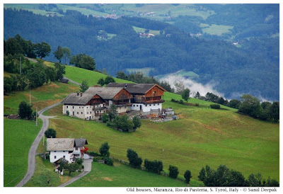
Along the road, there were some old wooden farm-houses with barns, like the one in the image below.

An old farm house, Maranza (Rio di Pusteria, Alto Adige, Italy) - Images by Sunil Deepak

The view of the tiny houses filled with flowers across the green hills was beautiful. In one of the hotels below, we could even see a swimming pool with people sitting around in bikinis.

Our walk ended at the cabin-car station, which took the people to the top of the Gitschberg mountain about 800 metres above, almost like the difference between Rio di Pusteria and Maranza.

Gitschberg cabin-car station, Maranza (Rio di Pusteria, Alto Adige, Italy) - Images by Sunil Deepak

In winters these cabin-cars are used for reaching the skiing slopes. In the summer, tourists use them to go up to the mountain for the panoramic views. Our sky-lift free-pass was valid on these cabin-cars as well. However, as we only had that afternoon in Maranza, we decided not to go up to Gitschberg and instead explore the local surroundings.

Cabin-cars to Gitschberg, Maranza (Rio di Pusteria, Alto Adige, Italy) - Images by Sunil Deepak

We found a small family run restaurant near the cabin-car station, where we stopped for a coffee and a delicious cake, while watching the cabin cars going up and down.

A walk on the Panoramic road

In Maranza you have different options for walking and trekking. You can walk to Vals (Valles) and then take the cabin-car to go towards the skiing slopes of Jochtal. It is also possible to follow one of the trekking routes. For example, trekking route n. 16 takes you to Wiersehutte in about an hour and a half. More adventurous persons can take the trekking route to Seefeld lake, which requires about 4 hours of walking and mountain climbing.

Instead, we decided to be more relaxed and take one of the roads going up the hill in front of the cabin-car station - the road was called Via Panorama. With old wooden fences and occasional houses, it was a beautiful road (image below).

Via Panorama, Maranza (Rio di Pusteria, Alto Adige, Italy) - Images by Sunil Deepak

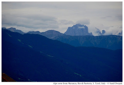
True to its name, Via Panorama also led us to beautiful views of the surrounding Alps as you can see in the image below.

Alp mountains around Maranza (Rio di Pusteria, Alto Adige, Italy) - Images by Sunil Deepak

Below us, to the left we could see the Maranza town and the San Giacomo church. It was an unhurried and relaxing walk. The road did go up and down, but it was not a tough walk.

A view of Maranza (Rio di Pusteria, Alto Adige, Italy) - Images by Sunil Deepak

From Via Panorama, passing through Viccolo Kossler, Via Aigner and Via Aussereck we went all around and came to the San Giacomo church from the back.

San Giacomo church, Maranza (Rio di Pusteria, Alto Adige, Italy) - Images by Sunil Deepak

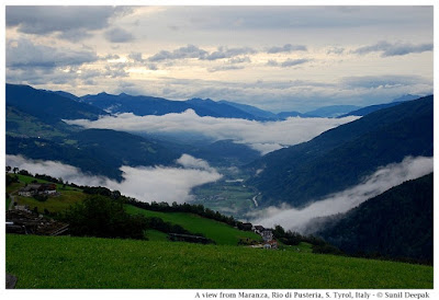
By this time, there were a few clouds hiding the sun. It felt colder and evening darkness was arriving. We could see some thick white clouds creeping in the valleys below.

A view of the valley, Maranza (Rio di Pusteria, Alto Adige, Italy) - Images by Sunil Deepak

So we decided that it was time for us to go down.We went back to the cabin-car station and took the sky-lift. The journey back to Rio, floating in the sky-lift was as thrilling as it was on the way up.

Conclusions

In my memories, the day spent in Maranza is an ideal holiday - filled with verdant hills, flowers and quaint houses.

I wish that we had more time to visit Gitschberg and Jochtal mountains. Perhaps we will have that opportunity during another holiday!

A weather-vane, Maranza (Rio di Pusteria, Alto Adige, Italy) - Images by Sunil Deepak

I want to close this post with an image (above) of a beautiful weather-vane I saw in Maranza - it has tiny statues of Snow-white and the seven dwarfs. 

***

Wednesday, 27 September 2017

Exploring the many splendors of Bundelkhand

Last year I visited some beautiful places in Bundelkhand in central India. However, you won't find "Bundelkhand" on the map of India since it is not a defined geographical area. Instead, it is a socio-cultural region, characterised by its linguistic, social and cultural traditions.

Chattris (cenotaphs) in Orchha, Bundelkhand region, central India - Images by Sunil Deepak

This region has some of the most beautiful forts and temples in India, though many of these are relatively unknown except to the locals. The erotic temples of Khajuraho are a UNESCO World Heritage site. Other important towns known to tourists are Gwalior, Jhansi and Orchha. The image above is from Orchha.

This post is an introduction to the Bundelkhand region. I hope that it will contribute to raising awareness about this region and discover some of its hidden treasures.

Geography of Bundelkhand

The northern part of this region lies in the state of Uttar Pradesh (purple in the map below) while its southern part lies in the state of Madhya Pradesh (green in the map).

Map of Bundelkhand region, central India - Images by Sunil Deepak

Bundelkhand lies between the Gangetic plains and the Vindhyachal mountains. It is marked by a barren hilly terrain. Its highest point has an altitude of 600 meters. Its isolated hills rising abruptly from the ground have been the sites for the forts of the local kings. Its rivers flow in a northeast direction to join the Yamuna River.

It is a Hindi speaking area. The Bundeli language is the most common of the Hindi dialects spoken in the area. It in turn consists of several sub-dialects.

A Brief History of Bundelkhand

Oral histories and legends of the region describe it as the ancient reign of king Luv, the son of Lord Rama. In the Pre-Buddhist period, this area came under the kingdom of Ujjain.

In the Buddhist period (around 500 BCE), this area was known as Chedi Janapada (literally "Ruled by the people") as shown in Thomas Lessman map of 500 BCE.

Thomas Lessman map of India, 500 BCE

Some centuries later, this area was also called "Dasarna" (the land of ten rivers) as shown in the Thomas Lessman map of 100 BCE below. Its principal rivers are the Kali Sindh, Betwa, Shahzad, Ken, Bagahin, Tons, Pahuj, Dhasan and Chambal. The Kali Sindh river marks the western boundary of Bundelkhand.

Thomas Lessman map of India, 100 BCE

In the 6th century CE during the Gupta empire, Huns from central Asia had come to this region. An inscription in Gwalior describes a sun temple built in the Gwalior fort by the Hun emperor Mihirakula. Till around 9th century, Bundelkhand was part of Pratihara kingdom which ruled from Kannauj.

Chandelas arrived here in the 9th century as the feudal lords of the Pratihara, however soon they became independent. They ruled Bundelkhand for around 300 years. Initially they ruled from Khajuraho and then shifted to Mahoba. They built the famous Khajuraho temples in the 10th century, and the fort and a few artificial lakes in Mahoba in the 11th-12th centuries. In late 12th century, as their power weakened, a part of Bundelkhand came under the Khangar dynasty, who took over the Jingarh fortress of the Chandelas and renamed it Garh Kundhar.

In early 13th century the Chandelas were defeated by the sultan of Delhi, Qutubuddin Aibek, who was of Turkish origins. After almost two centuries, in the 16th century, for a short period the Chandela dynasty rose again, but it could not last and during the reign of Akbar, the region passed under the Mughal empire.

As part of the empire, Bundelkhand was ruled by Rajput kings, who recognized the Mughal sovereignty.  (Below, Thomas Lessman map from 1500 CE showing the Rajput states). These kings are known as Bundela kings and this was the period, when the region got its name Bundelkhand. Bundela kingdoms started in Orchha, moved to Chattarpur and then to Jhansi.

Thomas Lessman map of India, 1500 CE

In 18th century, parts of Bundelkhand came under Maratha rule and in early 19th century, it passed under the East India Company till India's independence in 1947. After independence, the northern parts of Bundelkhand were made a part of Uttar Pradesh (UP) while the southern parts joined the state of Madhya Pradesh (MP).

Temples, Shrines and Dargahs of Bundelkhand

The region is predominantly Hindu. Earlier temples attest to the strong presence of Shaivism in the region with a number of Shiva temples. The image below shows an old Shiva temple in the lower parts of the Jhansi fort.

Old Shiva temple, Jhansi fort, Bundelkhand region, central India - Images by Sunil Deepak

The rise of Bhakti movement in the medieval period contributed to the spread of Vaishnav stream of Hinduism in Bundelkhand. For example, out of the 20 surviving temples of Khajuraho, 6 are dedicated to Shiva and 8 to Vishnu.

Parvati & Vishwanath temples, Khajuraho, Bundelkhand region, central India - Images by Sunil Deepak

Mahavir, the thirthankar of the Jains, was a contemporary of Buddha. Jainism has been very strong in Bundelkhand since ancient times with a large number of important temples. For example, the breath-taking Jain rock-temples (image below) near the Gwalior fort were sculpted during 5th-15th centuries CE.

Jain rock temples, Gwalior, Bundelkhand region, central India - Images by Sunil Deepak

Bundelkhand is also important for the Muslim Sufi shrines, such as the dargah of Hazrat Gous-e-Gawliori and Khawaja Khanoon Sahib in Gwalior, dargah of Sadan Shah in Lalitpur and dargah of Sundar Sain in Orchha (image below).

Sundar Sain sufi dargah, Orchha, Bundelkhand region, central India - Images by Sunil Deepak

In the Sufi tradition, there have been different Muslim poets in Bundelkhand, who wrote in Hindi and promoted a syncretic Hindu-Muslim culture. These included Miyan Tansen and Kare Beg Fakir in the 16th century, and En Sain and Mehboob in the 18th century. For example, Tansen wrote different poems about Krishna and Ganesh.

Forts of Bundelkhand

Bundelkhand region is full of ruins of magnificent fortresses and temples, many of which are known only to local persons and to academics.

For example, according to Dr Ramsajivan who wrote a PhD thesis on this theme in 2006, there are 41 important fortresses in Bundelkhand - Kalinjar, Ajaygarh, Rasin, Madfa, Sherpur Sevda, Rangarh, Tarhua, Bhuragarh, Mahoba, Sirsagarh, Jaitpur, Mangalgarh, Maniyagarh, Baruasagar, Orchha, Jhansi, Garh Kundhar, Chirgaon, Airch, Urai, Kalpi, Datiya, Badhoni, Gwalior, Chanderi, Chhattarpur, Panna, Singhorgarh, Rajnagar, Batiyagarh, Bajawaor (Jatashanker), Beergarh, Dhamoni, Patharigarh (Patharkachhar), Barigarh, Gaurhar, Kulpahar, Talbehat and Devgarh.

Walls of Jhansi fort, Bundelkhand region, central India - Images by Sunil Deepak

The descriptions of some of these forts, hardly visited by the tourists, are beautiful. For example - the ruins of Ajaygarh fort are located on a verdant hill and are difficult to reach while the Rangarh fort, built on a picturesque hill on an island of Ken river near Pangara, is surrounded by thick forests. Finding information about these places and reaching them is difficult.

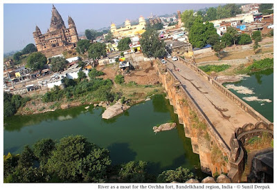
Building of the forts followed guidelines given in India's ancient architecture texts of Vaastu Shastra. These forts had thick high walls and were surrounded by moats or natural barriers such as rivers. The image below shows a branch of Betwa river that separates the Orchha fort from the town.

River Betwa separating Orchha fort from the town, Bundelkhand region, central India - Images by Sunil Deepak

Inside, these forts usually had ponds at different levels, both above and below, for their water supply. The ponds were usually accompanied by a temple. The image below shows a beautiful small pond from the Gwalior fort.

Pond and Bhim Singh Rana chhattri (cenotaph), Gwalior fort, Bundelkhand region, central India - Images by Sunil Deepak

Conclusions

Bundelkhand is not an easy region to visit. Being at the border of two states, many towns of the region are not well connected. It is a drought prone area and one of the poorest parts of India. Except for Gwalior, Jhansi, Orchha and Khajuraho, most of its rich history and monuments are ignored and neglected.

I hope that this post will stimulate some of you to visit and document some of its lesser known places and monuments.

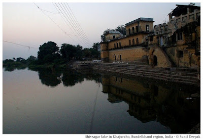
Shiv Sagar lake built by Chandela dynasty, Khajuraho, Bundelkhand region, central India - Images by Sunil Deepak

Let me conclude this post with an image (above) of the beautiful Shiv Sagar lake built under the Chandela dynasty in Khajuraho.

*** 

Tuesday, 19 September 2017

Holidays in the Pusteria valley in South Tyrol

South Tyrol (Alto Adige in Italian) region in the north-eastern Alps in Italy is a beautiful land with snow covered mountains, grassy meadows, amazing lakes and breath-taking panoramas. We visited the tiny mountain town of Rio di Pusteria in this region for a short holiday.

An evening view, Rio di Pusteria, South Tyrol, Italy - Images by Sunil Deepak

The image above shows an evening view of Rio di Pusteria, nestled among the Alps mountains.

Historical background & General information

Rio di Pusteria is an old market town on the Rienza river, located between the Isarco and Pusteria valleys. Near the town, a sluice gate on the river creates the Pusteria lake.

Pusteria lake on Rienza river, Rio di Pusteria, South Tyrol, Italy - Images by Sunil Deepak

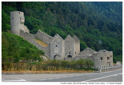
In olden times there was a toll station here, including a defensive fortress built in the 13th century. The ruins of this fortress are located towards the east of the city.

Ruins of the fortress, Rio di Pusteria, South Tyrol, Italy - Images by Sunil Deepak

Till the First World War, South Tyrol was a part of Austria. Thus, in this area, many persons speak German and all places have an Italian name and an Austrian name. For example, Rio di Pusteria is called Mühlbach (the mill on the torrent) by the German speakers.

Rio is a tiny town with less than 3,000 inhabitants. Its altitude varies from 777 to 1,414 metres. The city includes some neighbouring mountain areas, which are famous for their skiing-slopes.

Our holidays

We wanted to explore the nature in this region. Initially, we were thinking of staying in Bressanone city. However, we thought that to visit the lakes and the mountains, it would be better to stay in a smaller town, and thus we decided to stay in Rio. I did the online booking at hotel Rosenhof and we were very happy with our choice.

Hotel Rosenhof, Rio di Pusteria, South Tyrol, Italy - Images by Sunil Deepak

The hotel was beautiful and its owners were friendly. Our room on the top floor had a wonderful view of the surrounding mountains. The breakfast was huge and very satisfying. The hotel was close to the city centre and a couple of nice pizza restaurants.

Rio di Pusteria town

Rio is a tiny town, full of narrow cobbled streets and beautiful old houses with their balconies full of flowers.

City centre and the church bell tower, Rio di Pusteria, South Tyrol, Italy - Images by Sunil Deepak

The city centre has the St. Andrea church built in the Gothic style in the 14th century. It has an old part where the grandmother of Pope Benedict XIV, Maria Tauber Peintner was married in 1858.

Interior, St Andrea church, Rio di Pusteria, South Tyrol, Italy - Images by Sunil Deepak

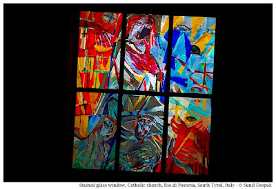
The church includes a new part, which has beautiful modern stained-glass windows.

New stained glass windows, St Andrea church, Rio di Pusteria, South Tyrol, Italy - Images by Sunil Deepak

The city centre also includes a sky-lift station from where you can take the cable car to Maranza and from there to other mountains. Persons staying in a hotel in Rio get a free travel card which allows unlimited journeys on the sky-lift. I will write about Maranza in another post.

Cable car of the sky-lift to Maranza, Rio di Pusteria, South Tyrol, Italy - Images by Sunil Deepak

Walks around Rio di Pusteria

There are different hiking trails starting from Rio including the one going to Selvaggio lake from Valles and another, going to Malga Fane-Alm. These trails are for the serious hikers.

If you do not wish to do strenuous hiking, you can go for a walk towards the fortress ruins or along the Via Holden, which goes along a torrent passing near the city centre. It passes under the railway bridge.

The railway bridge and the torrent, Rio di Pusteria, South Tyrol, Italy - Images by Sunil Deepak

A little further down, when the torrent joins the Pusteria river, you can proceed along the river bank on a forest path for a couple of kilometres. We went for a walk on this road and found it easy and yet very stimulating.

A walk along Via Holden, Rio di Pusteria, South Tyrol, Italy - Images by Sunil Deepak

Conclusions

During our stay in Rio di Pusteria, except for a couple of walks, we did not spend much time in the town. Rather we used it as our base to explore the nearby mountains and lakes in Maranza, Braies, Neves and Dobbiaco. Except for Maranza, we didn't have enough time to explore the different mountains through the sky-lift even if we had the free sky-lift pass. Still we loved this little town.

City centre, Rio di Pusteria, South Tyrol, Italy - Images by Sunil Deepak

It was one of our most memorable holidays. In fact, I would like to go back one day to Rio di Pusteria for another holiday and this time, spend more time exploring the mountains through the sky-lift!

***

Sunday, 10 September 2017

An afternoon discovering Nagaon in Assam

Nagaon is a tiny sleepy town in Assam. I visited it some time back for work. I remember it because it gave me an opportunity to observe the traditional Assamese fishing in Kolong river.

Bhuyapatti bridge, Nagaon, Assam, India - Images by Sunil Deepak

The image above shows the Bhoyapatty footbridge on the Kolong river on a misty evening in Nagaon.

Nagaon town

The little town of Nagaon, 94 km to the north-east of Guwahati in Assam, is known as the birthplace of Shrimanta Shanker Dev, a sixteenth century social and religious reformer who had a profound impact on Assamese people and culture. Actually Shanker Dev was born in Bordowa, about 17 km from Nagaon.

Kolong river passes through the city centre of Nagaon, and is a tributary of Brahmaputra river.

Along Kolong river, Nagaon, Assam, India - Images by Sunil Deepak

Reaching Nagaon is easy. Apart from the state buses, there are numerous private jeeps and vans starting from Khanapara in Guwahati and going to Nagaon. A.T. road, an important artery of transport in Assam, coming from Guwahati, passes through Nagaon.

I was in Nagaon for some work for just one day.

A Walk Along Kalong River

When I reached Nagaon, it was late afternoon. I found a hotel off the state highway 18, near the city bus stand. It was close to a footbridge on Kolong river, which went towards the Nowgaon Law College.

Online search about places to see in Nagaon did not provide any information. All the places to visit were outside the city, in the district or in the nearby areas - such as Kaziranga wildlife sanctuary, Laokhowa wildlife sanctuary, Chapanalla pond, Bordowa (birth place of Srimanta Shanker Dev) and Madhabthan (birthplace of Madhab Dev, a follower of Shrimanta Shanker Dev).

My work appointment was for the next day morning and I was free that afternoon. However, I was tired from the journey, and did not want to do anything tiring. Thus, I decided to take a slow walk along the Kolong river and discover a part of Nagaon town.

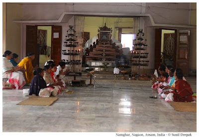
Close to the river there was a Naamghar, a Vaishnav praying place for the followers of Shrimanta Shanker Dev. Inside there were no statues. Instead the people prayed in front of the sacred book, Bhagwat Puran, which tells the story of Krishna. The book was kept in the centre of the temple, at the top of a pyramid like structure and lamps were lighted in front of it.

Naamghar near Kolong river, Nagaon, Assam, India - Images by Sunil Deepak

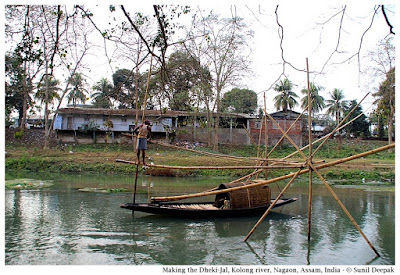
Dheki-Jal Traditional Fishing Nets

After visiting the Naamghar, I got on the footbridge over the river. From there I saw a man fixing a fishing net in the river. Such fishing nets, placed in rivers, lakes and ponds are a common sight in Assam. It was the first time I was seeing someone actually making the whole structure, so I walked along the river bank to look at it from close.

Fixing the net looked complicated. There were about a dozen bamboo poles that had to be arranged in such a way to create a cantilever mechanism in which two bamboo poles were tied at one end, while their other ends diverged to create a wide arc. These two poles were linked to a whole system of supporting bamboo poles, so that putting a weight at the tied end of the cantilever bamboos, raised up the divergent end, while removing the weight, brought down the divergent end to just below the water surface.

Traditional Dheki jal fishing net in Kolong river, Nagaon, Assam, India - Images by Sunil Deepak

After fixing the poles, the fisherman fixed the fishing net to the diverging part of the bamboos and then lowered the net in the water. He was clearly an expert at making this fishing net, deftly balancing the poles into position and then fixing them without any help. The whole thing took him almost two hours of work.

Traditional Dheki jal fishing net in Kolong river, Nagaon, Assam, India - Images by Sunil Deepak

He told me that that he had been doing this kind of fishing ever since he was 14 years old. He also explained that this was called the Dheki jal.

I have seen similar cantilever nets in the sea in Kochi (Kerala), where they are called the Chinese nets. The principle for making them seems to be same, though they remain fixed in one place while the net made by this fisherman was temporary. Every few days, he moved to another place, leaving the river and the fishes to regenerate.

I was really happy that I could witness the setting up of the traditional Dheki-jal. By the time, he had finished, it was already evening. I walked back to the footbridge and resumed my walk. Below me, I could see the fisherman's boat gently bobbling on the Kolong waters.

Traditional Dheki jal fishing net in Kolong river, Nagaon, Assam, India - Images by Sunil Deepak

Back to the walk along Kolong river

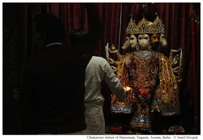
After crossing the footbridge to the northern bank of Kolong, I continued my walk along it till the Bhoyapatti footbridge and then went back to the southern bank of the river. Close to the river was a Hanuman temple with a "chimaeras" or a Bahurupi statue of Hanuman, where a priest was conducting an evening prayer (Aarti).

Chimaeras statue of Hanuman, Nagaon, Assam, India - Images by Sunil Deepak

Chimaeras is a mythical animal composed of different parts of animals and birds. One of the earliest examples of chimaeras in India is on an Indus Valley seal. One of my Italian friends who has been involved in excavations of some Indus Valley sites, uses the term "chimaeras" for Navagunjara-rupa of Krishna in Bhagwat Gita. I thought that showing Hanuman with different faces has the same concept and that is why I am calling it "chimaeras" statue of Hanuman.

Close to the Hanuman temple was the state bus stand of Nagaon. Passing through the bus station, I found myself at a Sai Baba temple at a street corner. Here too, an aarti was being conducted. However compared to the Hanuman temple, which was almost deserted, the tiny Sai Baba temple was packed with devotees.

Sai Baba temple, Nagaon, Assam, India - Images by Sunil Deepak

From the Sai Baba temple, I walked back to my hotel.

Shrimanta Shanker Dev Mission

Next day morning, I took an auto-rickshaw for Panigaon chariali on the AT road to visit the Shrimanta Shanker Dev Mission. With an eye hospital, a hostel for blind children, a disability centre for the distribution of technical appliances, a leprosy centre, an anganwadi training centre and many more activities, the Mission was a very active place.

Shrimanta Shanker Dev Mission, Nagaon, Assam, India - Images by Sunil Deepak

After discussions with the persons looking after the disability centre of the Mission, it was time for me to leave Nagaon.

Conclusions

Most persons just pass through Nagaon. Probably the only persons who stop are those who have families here or those who have some work.

It was a short visit and for me, the most memorable part of it was the time spent near the river to see the construction of the traditional Dheki Jal.

A Bihu straw sculpture, Nagaon, Assam, India - Images by Sunil Deepak

Let me conclude this post with an image of a giant sculpture of a bird made from straw in a field near Nagaon. Such straw sculptures are built as part of the celebrations of Bihu, a traditional Assamese festival.

***

This Year's Popular Posts