Showing posts with label Famous Places. Show all posts

Wednesday 27 September 2017

Exploring the many splendors of Bundelkhand

Last year I visited some beautiful places in Bundelkhand in central India. However, you won't find "Bundelkhand" on the map of India since it is not a defined geographical area. Instead, it is a socio-cultural region, characterised by its linguistic, social and cultural traditions.

Chattris (cenotaphs) in Orchha, Bundelkhand region, central India - Images by Sunil Deepak

This region has some of the most beautiful forts and temples in India, though many of these are relatively unknown except to the locals. The erotic temples of Khajuraho are a UNESCO World Heritage site. Other important towns known to tourists are Gwalior, Jhansi and Orchha. The image above is from Orchha.

This post is an introduction to the Bundelkhand region. I hope that it will contribute to raising awareness about this region and discover some of its hidden treasures.

Geography of Bundelkhand

The northern part of this region lies in the state of Uttar Pradesh (purple in the map below) while its southern part lies in the state of Madhya Pradesh (green in the map).

Map of Bundelkhand region, central India - Images by Sunil Deepak

Bundelkhand lies between the Gangetic plains and the Vindhyachal mountains. It is marked by a barren hilly terrain. Its highest point has an altitude of 600 meters. Its isolated hills rising abruptly from the ground have been the sites for the forts of the local kings. Its rivers flow in a northeast direction to join the Yamuna River.

It is a Hindi speaking area. The Bundeli language is the most common of the Hindi dialects spoken in the area. It in turn consists of several sub-dialects.

A Brief History of Bundelkhand

Oral histories and legends of the region describe it as the ancient reign of king Luv, the son of Lord Rama. In the Pre-Buddhist period, this area came under the kingdom of Ujjain.

In the Buddhist period (around 500 BCE), this area was known as Chedi Janapada (literally "Ruled by the people") as shown in Thomas Lessman map of 500 BCE.

Thomas Lessman map of India, 500 BCE

Some centuries later, this area was also called "Dasarna" (the land of ten rivers) as shown in the Thomas Lessman map of 100 BCE below. Its principal rivers are the Kali Sindh, Betwa, Shahzad, Ken, Bagahin, Tons, Pahuj, Dhasan and Chambal. The Kali Sindh river marks the western boundary of Bundelkhand.

Thomas Lessman map of India, 100 BCE

In the 6th century CE during the Gupta empire, Huns from central Asia had come to this region. An inscription in Gwalior describes a sun temple built in the Gwalior fort by the Hun emperor Mihirakula. Till around 9th century, Bundelkhand was part of Pratihara kingdom which ruled from Kannauj.

Chandelas arrived here in the 9th century as the feudal lords of the Pratihara, however soon they became independent. They ruled Bundelkhand for around 300 years. Initially they ruled from Khajuraho and then shifted to Mahoba. They built the famous Khajuraho temples in the 10th century, and the fort and a few artificial lakes in Mahoba in the 11th-12th centuries. In late 12th century, as their power weakened, a part of Bundelkhand came under the Khangar dynasty, who took over the Jingarh fortress of the Chandelas and renamed it Garh Kundhar.

In early 13th century the Chandelas were defeated by the sultan of Delhi, Qutubuddin Aibek, who was of Turkish origins. After almost two centuries, in the 16th century, for a short period the Chandela dynasty rose again, but it could not last and during the reign of Akbar, the region passed under the Mughal empire.

As part of the empire, Bundelkhand was ruled by Rajput kings, who recognized the Mughal sovereignty.  (Below, Thomas Lessman map from 1500 CE showing the Rajput states). These kings are known as Bundela kings and this was the period, when the region got its name Bundelkhand. Bundela kingdoms started in Orchha, moved to Chattarpur and then to Jhansi.

Thomas Lessman map of India, 1500 CE

In 18th century, parts of Bundelkhand came under Maratha rule and in early 19th century, it passed under the East India Company till India's independence in 1947. After independence, the northern parts of Bundelkhand were made a part of Uttar Pradesh (UP) while the southern parts joined the state of Madhya Pradesh (MP).

Temples, Shrines and Dargahs of Bundelkhand

The region is predominantly Hindu. Earlier temples attest to the strong presence of Shaivism in the region with a number of Shiva temples. The image below shows an old Shiva temple in the lower parts of the Jhansi fort.

Old Shiva temple, Jhansi fort, Bundelkhand region, central India - Images by Sunil Deepak

The rise of Bhakti movement in the medieval period contributed to the spread of Vaishnav stream of Hinduism in Bundelkhand. For example, out of the 20 surviving temples of Khajuraho, 6 are dedicated to Shiva and 8 to Vishnu.

Parvati & Vishwanath temples, Khajuraho, Bundelkhand region, central India - Images by Sunil Deepak

Mahavir, the thirthankar of the Jains, was a contemporary of Buddha. Jainism has been very strong in Bundelkhand since ancient times with a large number of important temples. For example, the breath-taking Jain rock-temples (image below) near the Gwalior fort were sculpted during 5th-15th centuries CE.

Jain rock temples, Gwalior, Bundelkhand region, central India - Images by Sunil Deepak

Bundelkhand is also important for the Muslim Sufi shrines, such as the dargah of Hazrat Gous-e-Gawliori and Khawaja Khanoon Sahib in Gwalior, dargah of Sadan Shah in Lalitpur and dargah of Sundar Sain in Orchha (image below).

Sundar Sain sufi dargah, Orchha, Bundelkhand region, central India - Images by Sunil Deepak

In the Sufi tradition, there have been different Muslim poets in Bundelkhand, who wrote in Hindi and promoted a syncretic Hindu-Muslim culture. These included Miyan Tansen and Kare Beg Fakir in the 16th century, and En Sain and Mehboob in the 18th century. For example, Tansen wrote different poems about Krishna and Ganesh.

Forts of Bundelkhand

Bundelkhand region is full of ruins of magnificent fortresses and temples, many of which are known only to local persons and to academics.

For example, according to Dr Ramsajivan who wrote a PhD thesis on this theme in 2006, there are 41 important fortresses in Bundelkhand - Kalinjar, Ajaygarh, Rasin, Madfa, Sherpur Sevda, Rangarh, Tarhua, Bhuragarh, Mahoba, Sirsagarh, Jaitpur, Mangalgarh, Maniyagarh, Baruasagar, Orchha, Jhansi, Garh Kundhar, Chirgaon, Airch, Urai, Kalpi, Datiya, Badhoni, Gwalior, Chanderi, Chhattarpur, Panna, Singhorgarh, Rajnagar, Batiyagarh, Bajawaor (Jatashanker), Beergarh, Dhamoni, Patharigarh (Patharkachhar), Barigarh, Gaurhar, Kulpahar, Talbehat and Devgarh.

Walls of Jhansi fort, Bundelkhand region, central India - Images by Sunil Deepak

The descriptions of some of these forts, hardly visited by the tourists, are beautiful. For example - the ruins of Ajaygarh fort are located on a verdant hill and are difficult to reach while the Rangarh fort, built on a picturesque hill on an island of Ken river near Pangara, is surrounded by thick forests. Finding information about these places and reaching them is difficult.

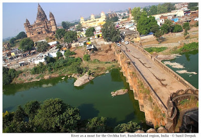
Building of the forts followed guidelines given in India's ancient architecture texts of Vaastu Shastra. These forts had thick high walls and were surrounded by moats or natural barriers such as rivers. The image below shows a branch of Betwa river that separates the Orchha fort from the town.

River Betwa separating Orchha fort from the town, Bundelkhand region, central India - Images by Sunil Deepak

Inside, these forts usually had ponds at different levels, both above and below, for their water supply. The ponds were usually accompanied by a temple. The image below shows a beautiful small pond from the Gwalior fort.

Pond and Bhim Singh Rana chhattri (cenotaph), Gwalior fort, Bundelkhand region, central India - Images by Sunil Deepak

Conclusions

Bundelkhand is not an easy region to visit. Being at the border of two states, many towns of the region are not well connected. It is a drought prone area and one of the poorest parts of India. Except for Gwalior, Jhansi, Orchha and Khajuraho, most of its rich history and monuments are ignored and neglected.

I hope that this post will stimulate some of you to visit and document some of its lesser known places and monuments.

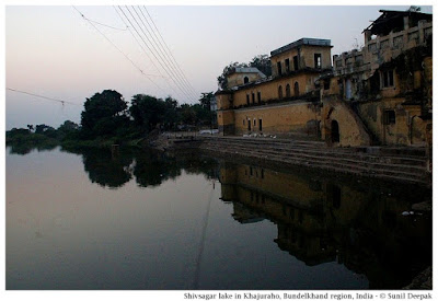
Shiv Sagar lake built by Chandela dynasty, Khajuraho, Bundelkhand region, central India - Images by Sunil Deepak

Let me conclude this post with an image (above) of the beautiful Shiv Sagar lake built under the Chandela dynasty in Khajuraho.

*** 

Thursday 27 July 2017

Beautiful conical-hat like houses of Alberobello

Old houses of Alberobello with black conical roofs that look like houses-with-hats, are an amazing spectacle. They represent an ancient tradition that has origins in pre-historical times. This post is about the magical Alberobello.

Trulli houses in Alberobello with signs painted on the roof - Photographs by Sunil Deepak

Reaching Alberobello

Alberobello (literally "Beautiful tree") is a tiny town in Apulia region of south Italy. Nearest national line train station is at Bari, 57 km away. From Bari, you can get a local train which takes you to Alberobello station in about 1.5 to 2 hours.

A 10-15 minutes walk from the railway station to Corso Trento e Trieste  and then towards Via Indipendenza-Largo Martellotta will take you to the old parts of the city characterized by the Trulli, the houses with black conical roofs.

A road sign on Via Indipendenza (image below) points to the stairs going up to a Belvedere terrace from where you can have an overview of the Trulli area.

Trulli houses in Alberobello - Belvedere - Photographs by Sunil Deepak

To see more Trulli houses, you can also visit the surrounding areas in the Itria valley such as Locorotondo and Cisternino. However, I think that the visual impact of these houses is seen best in Alberobello, where they are grouped together in one area. For example, the image below shows the Trulli houses in Cisterino.

Trulli houses in Cisternino, Itria Valley - Photographs by Sunil Deepak

Characteristics of Trulli houses

The Trulli are made of stones without using any mortar or binding cement in any part of the construction. This means that the builders need to select and cut the stones in a certain way and then fit them together so that they make a stable and water/wind-proof dwelling.

Trulli houses in Alberobello - Largo Martelotta road - Photographs by Sunil Deepak

This kind of house constructions were started during the Bronze age around 1500 BCE. For example in the island of Sardinia there are prehistoric buildings called Nauraghe, made just with stones without any mud or mortar to bind them. The houses in Alberobello are around 500 years old.

History of Alberobello

Alberobello city came up in 16th century along the banks of Cana river. People were ordered to build their houses only with dry stones and without using any mortar. This was done to avoid paying taxes to the kingdom of Naples which ruled this area, as dry stone-houses were treated as temporary buildings.

Since this area was rich in limestone and Karst-stone, people started building trulli houses. The image below shows a couple of pictures from 1920, showing this area when it was densely inhabited.

Trulli houses in Alberobello in 1920s - Photographs by Sunil Deepak

In the 20th century, when people had more money, they started demolishing the trulli houses to build modern cement-houses. About 200 trulli houses were thus demolished. Fortunately, during early 1990s, a new mayor of Alberobello stopped the demolitions and developed it as a tourist attraction.

Trulli of Alberobello

Roads going up and down the gentle hills around Viale Margherita in Alberobello are lined with trulli houses. In many of them there are souvenir shops for the tourists where they sell traditional crafts of Apulia.

Trulli houses in Alberobello - a sourvenir shop - Photographs by Sunil Deepak

Many houses have the sign of cross or the zodiac signs painted on their roofs.

Trulli houses in Alberobello with zodiac signs painted on the roof - Photographs by Sunil Deepak

There are different models of trulli including single one room buildings as well as, huge interconnected structures with different rooms and roofs.

Trulli houses in Alberobello - Different kind of roofs seen from Belvedere - Photographs by Sunil Deepak

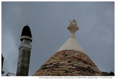
The way the roofs are designed also show many variations.

Trulli houses in Alberobello - roof  designs - Photographs by Sunil Deepak

Many trulli houses are still inhabited. I met a person called Mr Sebastiano, who invited me inside his house to show it. He is retired and has grown up in the same house. As you can see in the image below, it is a simple but comfortable house from inside. It has a living room with a fireplace on one side and a tiny bedroom (separated by a curtain) a separate kitchen and a bathroom.

Trulli houses in Alberobello -Sebastiano house - Photographs by Sunil Deepak

Even the Sant Antonio (St. Anthony) church in this area has roofs built like Trulli, though it is not a real trulli building.

Trulli houses in Alberobello - St Anthony church - Photographs by Sunil Deepak

Art of Alberobello

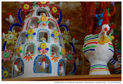
There are many souvenir shops selling local art work in Alberobello. I loved the art work in one such shop run by a lady called Maria Caporaso. Two examples of her art are presented below.

Alberobello - Art at Maria Caporaso shop - Photographs by Sunil Deepak

Alberobello - Art at Maria Caporaso shop - Photographs by Sunil Deepak

Conclusions

The traditional trulli houses of Alberobello with their black conical roofs make the old town look like a globlin-land from a children's book. I adored this city and its atmosphere.

The countryside around it is famous for its olive trees and oil. The sea is not very far and has amazing colours. There are many small characteristic towns nearby including the incredible city-in-white Ostuni. If you are planning an Italian holiday which is outside the famous big tourist cities, this is a great area for it.

Alberobello - a street of old town with trulli houses - Photographs by Sunil Deepak

The last bit of information is for the Bollywood lovers - a part of the song "Khuda Jaane" from the Bollywood film "Bachna Ae Haseeno" with Ranbir Kapoor and Deepika Padukone was shot here in Alberobello.

***

Saturday 10 June 2017

Fifty Shades of Green in Munnar

Munnar in Kerala with its gently rolling hills covered with rolling mists and neat rows of tea-plants is one of the most beautiful places in India. Recently I was there for a short holiday, recovering from an intensive Ayurvedic treatment. I have come back enchanted from this visit.


The infinite hues of green cut into squares and arranged in neat rows of the tea gardens draped over the hills and valleys are always the same and yet different, every time a source of joy and wonder.

MUNNAR HISTORY

During British colonial period, Munnar was a part of the Travancore estate. At that time it was mainly forest area with some agriculture and it belonged to the Poonjar family. John Munro, the British resident and Dewan of Travancore between 1810 to 1814, had visited different parts of the estate including Munnar, leaving descriptions which later helped in its use for the tea plantations.

In 1833, when the agreement for the supply of tea between China and England ended, the British started the search for alternative places in India to grow tea. Tea plants were stolen from China and brought to India. Native tea varieties were also identified in Assam. During 1850s the first Indian tea plantations were tried in the north especially around Darjeling in West Bengal and Sadiya in Assam. The first tea plantation in Munnar is credited to A. H. Scharp in 1880. Tea garden workers were brought from Tamilnadu, mainly poor peasants and tribals. Gradually tea plantations expanded all around Munnar.


MY VISIT TO MUNNAR

I was at an Ayurvedic hospital in Kothamangalam for a knee pain. After treatment, I was told to give rest to my joints for a few days. Since Munnar was close, I decided to go there. I stayed at SMM Lodge near the old KRTC bus stand, which meant that I was just outside the main town in a calm place with beautiful views. The image below shows a tea garden about 1 km from the hotel.

I took some leisurely walks in the city. I also made two tourist trips around Munnar - one to the south-west, going towards Pallivasal and the other to south-east, going towards Devikulam. Here is a brief presentation of the places that I visited during my stay.

MUNNAR TOWN

The old town of Munnar is located to the south along the Muthirappuzha river and extends from the old KRTC bus station to the bridge near the Christ church. The new Munnar is more developed with more shops and traffic and is to the north. Since I was staying in old Munnar, I only had glimpses of the new town while passing from there in an autorickshaw. It looked like any other town, full of shops, restaurants and noise. Probably it has some temples or other places to see, but I did not explore it.

I visited the Parvathi Amma temple and the Christ church in the old town. Just after the KRTC bus stand there is also the Blossom Park (Hydel park), but I did not visit it.

Parvathy Amma temple is a Hindu temple dedicated to Parvati, the consort of Lord Shiva. It is built in the south-Indian style with statues of different goddesses on the temple dome as shown in the image below. It is supposed to be very old.


In the courtyard next to the temple is an area for Shiva devotees with nine statues of Shiva.


Christ church is the oldest church of Munnar. A stone in the back-wall of the church explains that its foundation was laid by Sir Alexander Kay Muir, Baronet of Deanston (Glasgow, UK) in 1910. It is a simple church on the top of a hill with beautiful views of Munnar city and some nice stained-glass windows.


SOUTH-WEST TOWARDS PALLIVASAL

The road coming from Kochi, passing through Pallivasal, reaches south of Munnar. Along this road, a couple of kilometres before Munnar, a bridge across Muthirappuzhar river leads to a hill.


A climb along the hill on the right side after this bridge, overlooking the tea gardens in Pallivasal, brought me to Pothamedu View Point. I did this trip with an auto-rickshaw as I didn't want to strain my knees.


Further down this road, around 5 km from Munnar, a side road in Pallivasal took me to Atukkad water falls. The image below shows an overview of the whole area along with the water falls (towards the right edge of the image). When I visited it, the rains had not yet started and there was little water in the waterfall. Reaching the falls is difficult, so most people stop at a place on the hill from you can see the water fall, without going all the way down to the falls.


On the whole this visit towards Pallivasal was disappointing. For me, the most beautiful places on this visit were the tea gardens on the way.

SOUTH-EAST TOWARDS DEVIKULAM

A road going towards east from New Munnar will take you towards Devikulam, passing through Mathupetti and Kundala dams on Mathurippuzhar river, and then going up to Top Station at the border between Kerala and Tamil Nadu.

As for the visit to Pallivasal, the views of the tea gardens were breathtaking. The image below shows a view of the waters from the Mathupetty dam.


After Mathupetty dam, our next stop was Echo Point where the configuration of the river banks provides a good echo. Here, young persons were busy shouting and taking selfies.


Then we stopped at Kundala dam which has beautiful views of the mountains. Along the dam there are shops and restaurants and people stopped here for picnics.


Our last stop was Top Station which has beautiful views of higher mountains around Munnar. It is 32 Km from Munnar, and because of the stops on the way, the journey can take upto one and half hour. It is located slightly less than 1900 metres and from here, the views of Western Ghats and Theni valley in Tamil Nadu are amazing.  


There were some other places to visit on this visit such as the rose garden and the botanical gardens. However, I did not visit them.

WILD LIFE IN MUNNAR

Munnar provides a lot of opportunities for observing nature. During my walks in the city, I could observe numerous birds. On the visit to Devikulam, we were lucky to see a couple of female elephants with baby elephants.


TEA GARDEN WORKERS

After visiting a number of tea gardens in Assam, I was also curious about visiting the tea garden workers in Munnar and to learn about their lives. The opportunities to visit them came in Old Munnar itself where the side roads took me to areas where tea garden workers lived.


I also visited some houses of tea garden workers in Yellapetty in Devikulam. It was difficult to communicate since they did not speak Hindi or English. However, I was fortunate to find an auto driver, who spoke English, who had grown up in a tea garden and whose father and brother still worked in a tea garden. Compared to the situation in the north-east of India, my impression was that the tea garden workers had much better living and working conditions in Munnar. The image below shows a housing area for tea garden workers in Old Munnar town.


CONCLUSIONS

My visit to Munnar was a last minute decision. Since I like quiet and beautiful views, I am glad that I chose to stay in Old Munnar, away from the shops and noise of New Munnar.

Though I did make some tourist visits around Munnar, I usually avoided walking so I visited a limited number of places.

My most beautiful memories of Munnar are those of the tea gardens spread over hills and valleys. The last image of this post shows the morning mists in the hills of Devikulam. 


***

Sunday 4 June 2017

Street Artists of Ferrara

Ferrara is one of the most beautiful cities in northern Italy. Its medieval city centre has been declared a World Heritage of Humanity. In August every year, the city centre is filled by the colourful street artists (buskers) coming from different countries for the Annual Buskers Festival.


However, Ferrara is not just about the street artists. It also has many beautiful buildings and monuments. This post explains about some of the key places to see in the city, especially during the Buskers Festival.

History of Ferrara

The history of the medieval and renaissance city of Ferrara is closely bound to the Este family. Their castle is the symbol of the city. For about two centuries the splendour and richness of Ferrara matched other famous cities like Florence and Venice or with other great European courts in France or Spain.

Ferrara city grew up around a ford over the River Po. With its increasing prosperity, famous artists and intellectuals came to the city during the Italian Renaissance in the 15th and 16th centuries. Over time, the encircling walls of the medieval town were extended to accommodate urban growth, resulting in one of the first planned European cities where the medieval part of the town merged seamlessly with the new areas.

Red and pink colours dominate in Ferrara city centre and is the city of bicycles. It is on the Bologna-Venice railway line and easy to reach. A 15 minutes walk from the railway station will bring you to the Este castle and the city centre. The city has numerous hotels and B&B for the tourists.

Buskers Festival

The Annual Buskers Festival brings street artists including musicians, acrobats, clowns, illusionists and dancers, from the different parts of the world. It is held over a ten days period in August of each year. In 2017, this festival will be held from 17 to 27 August. The festival has street artists exhibiting along the winding medieval streets of the city centre. It is one of the best periods to visit Ferrara.

Este Castle

This beautiful castle complete with towers, moat and draw-bridges was built in 1385 and then expanded over the successive centuries.


The castle holds a museum and beautiful rooms with paintings, sculptures and frescoes. It includes hanging gardens built on a terrace. It is also a venue for different exhibitions and cultural events. For example, around Christmas the castle holds an exhibition of Christmas cribs from different parts of the world.


The castle is surrounded by different squares which are also venues for different events during the year. The image below presents the castle seen from the Savonarola square with a statue of Friar Girolamo Savonarola.


St George Cathedral of Ferrara

It is a beautiful building in pink and white marble, a short walk from the castle. Its construction was started in 1135, initially in the Romanic style which can still be seen in the facade. The entrance shows scenes from hell and heaven. Over the entrance sits archangel Gabriel with a balance in his hands. In the image below you can see the cathedral facade with a group of musicians during the Buskers festival in the foreground.


Inside, the cathedral is richly decorated in Baroque style and has different beautiful paintings and sculptures. Of special interest is a 16th century fresco by Bastiniano inspired by the famous painting of Michelangelo in the Sistine chapel in Vatican.


The cathedral was damaged by the allied bombings during the second world war and has been reconstructed. Next to the Cathedral is one of the largest and most beautiful squares of Ferrara called the Trento and Trieste square. From the square you can also see the 15th century pink and white banded bell tower of the cathedral. The image below shows the square during an open-air antiquarian market.


On the other side of Trento and Trieste square once there used to another famous medieval building, Reason Palace, which was damaged during the second world war and replaced by a modern building. It's tower was built in the second half of 15th century and use to hold the Bell of the Reason. In 1864, a clock was placed on it. After the second world war, enlargement of the road brought this tower in the middle of the street and is known as the Clock Tower.


Municipal Square and Staircase of Honour

On the opposite side of the road across from the cathedral, a high arched entrance called il Voltone leads to the Municipal Square. Before the construction of the Este Castle, the noble Este family used to live in the building of this square, marked by a beautiful marble staircase. The image below shows the Municipal Square during the Buskers Festival with the Staircase of Honour in the background.


Above the Voltone arched entrance, there are two statues - a bronze statue of Borso d'Este (Este treasury) and a statue of Nicholas the III from the Este family sitting on a horse, shown in the image below.


Diamond Palace

The urban expansion of Ferrara during the renaissance period led to the construction of new buildings outside the medieval town. Among these is the Diamond Palace built in 1492, named so because of diamond shaped cones covering its external walls. The Diamond Palace holds the city art museum and is the venue of  art exhibitions.


Monumental Water Reservoir

Closer to the railway station in the 24th May Square, there is another important site of Ferrara - the Monumental Water Reservoir with Acquedotto which collects and supplies water to the city. It is a tall round structure with columns, resembling a temple and holds a beautiful fountain showing the origins of river Po shown as a beautiful woman.


The park near the water reservoir also has a monument remembering the first war of independence of Italy against the Austrians, showing the historical "Bersaglieri of Po" unit of Italian military. The Bersaglieri wear a cap with a long plume. It is the work of the sculptor Fiorenzo Bacci.


Medieval Streets of Ferrara

Apart from the monuments mentioned above, the narrow and twisting cobbled medieval streets of Ferrara around the cathedral and clock tower are worth looking at.


Conclusions

Ferrara is a gem of a city in north Italy. Most tourists to Italy think only of Rome, Venice, Florence and Pisa. However, if you have a little time to visit it, Ferrara is definitely worth a visit.

The last image of this post (above) shows the Corso Martiri della Liberta, the main street in the centre of Ferrara with Voltone on the left and the Este Castle behind it. This part of the city is closed to cars and vehicles.

***

Popular Posts