Showing posts with label Monuments. Show all posts

Wednesday 27 September 2017

Exploring the many splendors of Bundelkhand

Last year I visited some beautiful places in Bundelkhand in central India. However, you won't find "Bundelkhand" on the map of India since it is not a defined geographical area. Instead, it is a socio-cultural region, characterised by its linguistic, social and cultural traditions.

Chattris (cenotaphs) in Orchha, Bundelkhand region, central India - Images by Sunil Deepak

This region has some of the most beautiful forts and temples in India, though many of these are relatively unknown except to the locals. The erotic temples of Khajuraho are a UNESCO World Heritage site. Other important towns known to tourists are Gwalior, Jhansi and Orchha. The image above is from Orchha.

This post is an introduction to the Bundelkhand region. I hope that it will contribute to raising awareness about this region and discover some of its hidden treasures.

Geography of Bundelkhand

The northern part of this region lies in the state of Uttar Pradesh (purple in the map below) while its southern part lies in the state of Madhya Pradesh (green in the map).

Map of Bundelkhand region, central India - Images by Sunil Deepak

Bundelkhand lies between the Gangetic plains and the Vindhyachal mountains. It is marked by a barren hilly terrain. Its highest point has an altitude of 600 meters. Its isolated hills rising abruptly from the ground have been the sites for the forts of the local kings. Its rivers flow in a northeast direction to join the Yamuna River.

It is a Hindi speaking area. The Bundeli language is the most common of the Hindi dialects spoken in the area. It in turn consists of several sub-dialects.

A Brief History of Bundelkhand

Oral histories and legends of the region describe it as the ancient reign of king Luv, the son of Lord Rama. In the Pre-Buddhist period, this area came under the kingdom of Ujjain.

In the Buddhist period (around 500 BCE), this area was known as Chedi Janapada (literally "Ruled by the people") as shown in Thomas Lessman map of 500 BCE.

Thomas Lessman map of India, 500 BCE

Some centuries later, this area was also called "Dasarna" (the land of ten rivers) as shown in the Thomas Lessman map of 100 BCE below. Its principal rivers are the Kali Sindh, Betwa, Shahzad, Ken, Bagahin, Tons, Pahuj, Dhasan and Chambal. The Kali Sindh river marks the western boundary of Bundelkhand.

Thomas Lessman map of India, 100 BCE

In the 6th century CE during the Gupta empire, Huns from central Asia had come to this region. An inscription in Gwalior describes a sun temple built in the Gwalior fort by the Hun emperor Mihirakula. Till around 9th century, Bundelkhand was part of Pratihara kingdom which ruled from Kannauj.

Chandelas arrived here in the 9th century as the feudal lords of the Pratihara, however soon they became independent. They ruled Bundelkhand for around 300 years. Initially they ruled from Khajuraho and then shifted to Mahoba. They built the famous Khajuraho temples in the 10th century, and the fort and a few artificial lakes in Mahoba in the 11th-12th centuries. In late 12th century, as their power weakened, a part of Bundelkhand came under the Khangar dynasty, who took over the Jingarh fortress of the Chandelas and renamed it Garh Kundhar.

In early 13th century the Chandelas were defeated by the sultan of Delhi, Qutubuddin Aibek, who was of Turkish origins. After almost two centuries, in the 16th century, for a short period the Chandela dynasty rose again, but it could not last and during the reign of Akbar, the region passed under the Mughal empire.

As part of the empire, Bundelkhand was ruled by Rajput kings, who recognized the Mughal sovereignty.  (Below, Thomas Lessman map from 1500 CE showing the Rajput states). These kings are known as Bundela kings and this was the period, when the region got its name Bundelkhand. Bundela kingdoms started in Orchha, moved to Chattarpur and then to Jhansi.

Thomas Lessman map of India, 1500 CE

In 18th century, parts of Bundelkhand came under Maratha rule and in early 19th century, it passed under the East India Company till India's independence in 1947. After independence, the northern parts of Bundelkhand were made a part of Uttar Pradesh (UP) while the southern parts joined the state of Madhya Pradesh (MP).

Temples, Shrines and Dargahs of Bundelkhand

The region is predominantly Hindu. Earlier temples attest to the strong presence of Shaivism in the region with a number of Shiva temples. The image below shows an old Shiva temple in the lower parts of the Jhansi fort.

Old Shiva temple, Jhansi fort, Bundelkhand region, central India - Images by Sunil Deepak

The rise of Bhakti movement in the medieval period contributed to the spread of Vaishnav stream of Hinduism in Bundelkhand. For example, out of the 20 surviving temples of Khajuraho, 6 are dedicated to Shiva and 8 to Vishnu.

Parvati & Vishwanath temples, Khajuraho, Bundelkhand region, central India - Images by Sunil Deepak

Mahavir, the thirthankar of the Jains, was a contemporary of Buddha. Jainism has been very strong in Bundelkhand since ancient times with a large number of important temples. For example, the breath-taking Jain rock-temples (image below) near the Gwalior fort were sculpted during 5th-15th centuries CE.

Jain rock temples, Gwalior, Bundelkhand region, central India - Images by Sunil Deepak

Bundelkhand is also important for the Muslim Sufi shrines, such as the dargah of Hazrat Gous-e-Gawliori and Khawaja Khanoon Sahib in Gwalior, dargah of Sadan Shah in Lalitpur and dargah of Sundar Sain in Orchha (image below).

Sundar Sain sufi dargah, Orchha, Bundelkhand region, central India - Images by Sunil Deepak

In the Sufi tradition, there have been different Muslim poets in Bundelkhand, who wrote in Hindi and promoted a syncretic Hindu-Muslim culture. These included Miyan Tansen and Kare Beg Fakir in the 16th century, and En Sain and Mehboob in the 18th century. For example, Tansen wrote different poems about Krishna and Ganesh.

Forts of Bundelkhand

Bundelkhand region is full of ruins of magnificent fortresses and temples, many of which are known only to local persons and to academics.

For example, according to Dr Ramsajivan who wrote a PhD thesis on this theme in 2006, there are 41 important fortresses in Bundelkhand - Kalinjar, Ajaygarh, Rasin, Madfa, Sherpur Sevda, Rangarh, Tarhua, Bhuragarh, Mahoba, Sirsagarh, Jaitpur, Mangalgarh, Maniyagarh, Baruasagar, Orchha, Jhansi, Garh Kundhar, Chirgaon, Airch, Urai, Kalpi, Datiya, Badhoni, Gwalior, Chanderi, Chhattarpur, Panna, Singhorgarh, Rajnagar, Batiyagarh, Bajawaor (Jatashanker), Beergarh, Dhamoni, Patharigarh (Patharkachhar), Barigarh, Gaurhar, Kulpahar, Talbehat and Devgarh.

Walls of Jhansi fort, Bundelkhand region, central India - Images by Sunil Deepak

The descriptions of some of these forts, hardly visited by the tourists, are beautiful. For example - the ruins of Ajaygarh fort are located on a verdant hill and are difficult to reach while the Rangarh fort, built on a picturesque hill on an island of Ken river near Pangara, is surrounded by thick forests. Finding information about these places and reaching them is difficult.

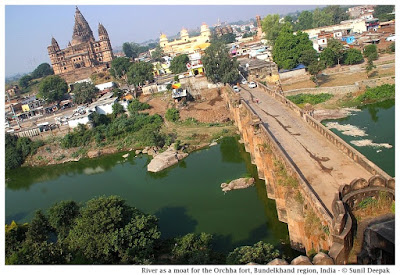
Building of the forts followed guidelines given in India's ancient architecture texts of Vaastu Shastra. These forts had thick high walls and were surrounded by moats or natural barriers such as rivers. The image below shows a branch of Betwa river that separates the Orchha fort from the town.

River Betwa separating Orchha fort from the town, Bundelkhand region, central India - Images by Sunil Deepak

Inside, these forts usually had ponds at different levels, both above and below, for their water supply. The ponds were usually accompanied by a temple. The image below shows a beautiful small pond from the Gwalior fort.

Pond and Bhim Singh Rana chhattri (cenotaph), Gwalior fort, Bundelkhand region, central India - Images by Sunil Deepak

Conclusions

Bundelkhand is not an easy region to visit. Being at the border of two states, many towns of the region are not well connected. It is a drought prone area and one of the poorest parts of India. Except for Gwalior, Jhansi, Orchha and Khajuraho, most of its rich history and monuments are ignored and neglected.

I hope that this post will stimulate some of you to visit and document some of its lesser known places and monuments.

Shiv Sagar lake built by Chandela dynasty, Khajuraho, Bundelkhand region, central India - Images by Sunil Deepak

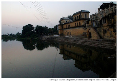
Let me conclude this post with an image (above) of the beautiful Shiv Sagar lake built under the Chandela dynasty in Khajuraho.

*** 

Friday 19 May 2017

Do not forget Hiroshima Bomb

It would be difficult to find someone who has never heard of the nuclear bomb in Hiroshima in Japan during the Second World War. Recently I was in Okayama and Hiroshima was not very far. Thus, I took a bus and went there for a day-trip.


The image above presents my favourite sculpture from the Peace Memorial Park of Hiroshima. I loved the tender expression on the woman's face, the golden sliver of the moon and the baby playing with a trumpet. In a poetic way, I think that it sums up very well why we need peace in the world and why we must never forget Hiroshima.

Bomb in Hiroshima

During the Second World War Japan bombed Pearl Harbour and USA retaliated by bombing Hiroshima and then, three days later, Nagasaki. Hiroshima Bengaku Hall was one important building, parts of which were left standing after the nuclear bomb. This hall could be seen next to Ota river in the old images of the bombing site (below) taken in 1945.


The uranium bomb called "Little Boy" had exploded around half a km above Hiroshima. In an area of 2 km around the explosion, all buildings were razed to ground, though houses in a 7 km radius were damaged. Only a few buildings in reinforced concrete survived. More than a hundred thousand persons died in Hiroshima, about 50% on the day of bombing and the remaining due to its after-effects.

Across the Ota river, today a plaque shows a picture of the Genbaku dome building before the bombing (image below).


Hiroshima Today

Today Hiro (broad) Shima (island) has a population of more than 1 million persons and is the biggest city in south Japan. It is a modern city full of sky-scrappers.


Ota river as it reaches near the sea, it divides into different branches (Enko, Motoyasu, Tenma, etc.), twisting, curving and encircling the land in a network of rivers and canals, criss-crossing the Hiroshima town. In 1949 it was decided to build a Memorial Park in this place, which lies in a small island created by Ota river and its branches. This post is about this A-Bomb Memorial Park, also called the Peace Memorial Park.

I was staying at Okayama and took an early morning bus to Hiroshima. The views of the verdant hills and mountains around the highway with occasional glimpses of the sea, was the notable feature of this one and half hour journey. The Ryobi bus dropped me at the corner of Heiwa Odori street, around 200 metres from the Memorial Park.

Genbaku Dome

The ruins of the Hiroshima Prefactural Industrial Promotion hall, called Genbaku hall, is the iconic symbol of Hiroshima. Its skeletal round dome at the top is called the A-Bomb dome. The black signs of  fire, the twisted metal staircase at its back and its blown out windows, doors and roofs are somber reminders of that 6 August morning of 72 years ago when the bomb had exploded.

The Genbaku dome is the only building of this part of old Hiroshima that has been left as it was that day.


Looking at the Genbaku dome affected me deeply, almost to the point of crying. It also made me think and despair about the number of countries that continue to make ever-bigger and ever-potent nuclear bombs. I thought of the words of Israeli historian and author Yuval Noah Harari:
In a xenophobic dog-eat-dog world, if even a single country chooses to pursue a high-risk, high-gain technological path, others will be forced to do the same, because nobody could afford to remain behind. In order to avoid such a race to the bottom, humankind will probably need some kind of global identity and loyalty.
Behind the dome, in the same complex, there is a central fountain with pillars arranged in a circle, that also bear the signs of the nuclear bomb.


Around the Genbaku dome, there are a number of small monuments. The first is the Red Bird monument, a literary monument to remember Miekuchi Suzuki of Hiroshima, who was a writer and the founder of a children's magazine called Akai Tori (the Red Bird). He is called the father of children's literature in Japan. The sculptures are by Katsuzo Entsuba, and were installed in 1964.


The Jizoson tombstone is a relic from the bombing,  placed in a building near the A-Bomb Dome. Jizoson is a Shinto deity that protects children. It was from a tombstone in a Jisenji temple. Part of the tombstone behind the statue remained smooth while other parts exposed to the thermal rays became rough.


The Student Memorial Tower is a pagoda-like monument in concrete with an angel in black stone at the base and sculptures of pigeons sitting on the top. It is located behind the Genbaku dome. On its sides there were colourful shide (streamers) of Orizuro (paper cranes), often placed near shrines, memorials and tombstones in Japan. At its back there were black stone panels with scenes showing the work of student volunteers in Hiroshima.


The other monuments mentioned below are scattered in different parts of the Memorial Park built across the river.

Peace Flame

The Peace Flame was lit in 1964 with the pledge that it will remain lit until all nuclear bombs on the planet are eliminated and the earth is free of nuclear bombs.


Memorial Cenotaph

The Cenotaph is an empty tomb to remember the persons who died in the bombing. It is located near the center of the park and is a concrete, saddle-shaped monument. The stone under the arch has the names of all of the people killed by the bomb. It was built on the open field and inaugurated on August 6, 1952. In the image below you can see the flame and the Genbaku dome seen from the Cenotaph arch.


Children's Peace Monument

This monument has a central pillar with a girl standing at the top holding in her hands an Orizuro paper crane. There are two more figures of children on the sides of the pillar.


It represents the story of a girl called Sasaki Sadako who had radiation sickness due to the bombing and believed that if she could make one thousand Orizuro she will be cured. However, Sasaki did not survive.


This monument remembers her and the other children who died in the bombing. People place streamers of paper cranes near this monument.

Peace Bell & Peace Clock

There are different bells in the Memorial park and museum. One of these bells placed in the garden has the words "Know yourself" written in Greek, Japanese and Sanskrit.

Every morning at quarter past eight, the time of the bombing, a clock placed on a metal tower near the park entrance, plays a peace prayer.

Prayer Monument

This monument has a sculpture of a couple with a child. It was created by artist Yoshizumi Yokoe in 1960. In front of the monument is a stone with a poem by a Hiroshima-born poet called Atsuo Oki, whose title is "Praying for peace and peaceful repose of the departed souls".


National Peace Memorial Hall

This underground hall designed by Kenzo Tange was built by the national government of Japan in 2002. It presents the stories of the bomb survivors and their old photographs. The image below shows a fountain built at the top of the hall.


Hiroshima Flower Festival

This festival is held in the first week of May each year in the Peace Memorial Park. When I visited Hiroshima in the last week of April, they had started preparing the flower for this festival but it was not yet complete. The image below shows the preparation of the flower.

Mother and Child in the Storm

This is another beautiful sculpture in the Peace Memorial Park expressing the hope for peace by the ordinary people. It was made by the artist Shin Hongo for the women associations of Hiroshima in 1960.


Conclusions

Every monument and sculpture in the Peace Memorial Park of Hiroshima is about peace, hope, and prayers. Yet in spite of the sufferings of thousands of persons, we continue to live in a world that threatens new man-made disasters and catastrophes. The lessons from the holocaust of the Jews or the atomic bombing of Hiroshima, are forgotten. So what should we do as individuals?

I believe that at individual level only we can promote a culture of respectful dialogue. The visit to Hiroshima was a reminder to renew my personal commitment for a culture of non-violence, the ideals of Mahatma Gandhi and the search for peace. I understand that this does not stop people fuelled by ignorance or hate or bigotry, but still as an individual I prefer to choose peace and dialogue.

I want to conclude this post with the picture of an old man who was sitting near the river bank behind the Genbaku dome, feeding the birds from his hands.


***

Wednesday 8 March 2017

A Walking Tour of Florence

Florence ("Firenze" in Italian) is famous for its architecture and art by master artists from the renaissance period like Michelangelo and Leonardo da Vinci. This walking tour is for visiting the city centre in Florence. If you want to know about lesser known places in Florence, you can read my second post about lesser-known places in Florence.


The central part of Florence described in this post, is very compact and you can easily walk to all these places from the railway station.

Reaching Florence

Florence has two main railway stations – Santa Maria Novella and Rifredi. Santa Maria Novella (SMN) is the main railway station of Florence and is near the tourist areas explained in this post. If your train stops only at Rifredi, there are many local and regional trains, which can take you to SMN station, five minutes away (a walk from Rifredi to SMN would take more than 30 minutes).

At SMN, take the exit on the left and then take the underpass towards Santa Maria Novella church across the street.

Santa Maria Novella church in dramatic white marble and black granite, is a very beautiful church. If you have a little time, take a look at the front part of the church with a lovely square.

  
Cathedral (Duomo)

The next stop is the Duomo square with its cathedral. Follow Via Panzani and then Via dei Cerretani for reaching the Santa Maria del Fiore Cathedral. It is just a ten-fifteen minutes walk.

The square has the octagonal baptistery, the cathedral and the bell tower. The whole square is very beautiful. To appreciate its beauty, visit it in early morning or late evening of a weekday, when there are less tourists.


Made of white marble with lines of black, dark green and pink stones, the cathedral is a rich and colourful wedding-cake like building, absolutely marvelous, full of amazing marble statues on all sides. You can spend a lot of time here looking at the different statues and admiring their art.

Entrance to the eight-sided Baptistery requires a ticket and often there is a queue to go inside. Even if you do not go inside, take the time to look at its solid brass doors with some amazing bass-relief sculptures.

On the right side of the cathedral, there are street artists who make beautiful portrait sketches and are really quick. You may wish to get your portrait done as a take-away memory of the Florence visit.

Compared to the rich sculptures and the colours outside, inside the cathedral is relatively simple. It is huge. Remember to look up to see the rich paintings on the inside of the dome. If you have time, you can even climb to the top of the dome (requires a ticket) for an absolutely marvellous view of the city skyline and the surroundings.

Lords' Square (Piazza della Signoria)

In front of the Cathedral, Via dei Calzaiuoli on the right side will bring you to the most famous square of Florence – “Piazza della signoria” (Lords’ square). The square has many things to see - the statue of Cosimo on the horse, beautiful Neptune fountain, Palazzo Vecchio (Old Palace) museum and the open-air Loggia with some beautiful sculptures.

If you have some time, take a closer look at the sculptures in the square. For example, in the Neptune fountain, look at the way the horses are sculpted – you can even see the veins on their necks.


Old Palace has some incredible frescoes and stucco work. It is an important art museum. For people who do not have the time to visit the museum, you can look at the museum statues displayed in the Loggia in front of Old Palace.


Uffizi Museum 

Uffizi museum is in the narrow street next to the Loggia. Along the street, on both sides you will find the statues of all the important historical celebrities of Florence including Macchiavelli and Dante.

Uffizi is one of the most important art museums of the world. It has an enormous collection of art masterpieces from Renaissance period of Italy. If you have read Dan Brown’s bestseller based in Florence, “Inferno”, you may already know about the masterpieces of this museum.

You need at least half a day to visit it. Usually there is a long queue of tourists waiting to go inside the museums.


The Old Bridge (Ponte Vecchio)

The Old Bridge on the Arno river is the next stop of this essential tour of Florence. Just behind Uffizi road is Lungarno, the bank of Arno river. Turn right on Lungarno and you will see the old bridge.

The bridge is full of shops selling gold and jewellry and is always crowded. I love the backside of the shops on the Old Bridge, painted in different colours, hanging over the river.


Walking along the river on Lungarno is another favourite past time for me. Seagulls and canoes, and the reflections of the medieval churches on the river bank, make this a magical place.


So my advice is that if you have some time, do not rush, take deep breaths and admire the incredible beauty of this place where nature and man-made constructions come together in a such a wonderful way.

Boboli Gardens and Museum

If you still have time, you can go across the bridge and continue for a short distance along that road to reach Boboli gardens and its museum that play a key role in Dan Brown’s “Inferno”.


However, Boboli gardens (require a ticket) are huge, are on a hill and the visit needs at least half a day (not counting the visit to the museum). If you like going up and down the hills, Boboli Gardens have some lovely statues and fountains.

Conclusions

This essential walking tour of central Florence takes you to some of the most beautiful artistic places in the world. If you have time, you can spend a full day in each of them to look at and appreciate their paintings and sculptures.

Around the places described above, there are numerous small medieval streets and other places to see including  different old churches. Many of these not-so-famous churches also have so many beautiful sculptures and paintings.

***

Friday 10 February 2017

Discovering Redipuglia & Palmanova

This post is about exploring two little-known small towns, full of history and culture, located in the north-east of Italy - Palmanova and Redipuglia (pronounced Redipulia).


Adriatic coast of Italy, is a well-known summer-holiday destination. Every year, between June to August, towns like Caorle, Jesolo, Portogruaro, Bibione or Lignano, get full of tourists from different parts of Europe.

If you are holidaying in any of these places, you can also explore some of these neighbouring towns that are so rich in history, to add a touch of culture to your seaside holidays. During our holidays the Adriatic coast, one day we went to visit Palmanova and Redipuglia.

We started this trip in Bibione where we were staying for holidays and our first stop was Villa Manin, a fifteenth century villa near Codroipo. The journey through beautiful countryside and gentle hills took about an hour.

Stop at Villa Manin

The tiny town of Codroipo was first built in the Roman times. Villa Manin is in Passariano, a suburb of Codroipo. Though parts of this building are a thousand years old, it was mostly built in 17th and 18th centuries. It was the residence of the last Doge (head of state) of Republic of Venice, Ludovico Manin.

The king of France, Napoleon Bonaparte and his wife Josephine, had stayed in this house for about 2 months in 1797 when Napoleon's troops had come to "liberate" this part of Italy from the Austrians and the Papal rule.

The day we visited it, it was getting ready for a music concert by the famous American music group called "Kiss". Crowds of young persons were sitting outside its gate blocking the whole area. Thus it was not possible for us to visit it. So we continued our journey to Palmanova.

The Octagonal Square of Palmanova

Palmanova, a tiny town in the north-east of Italy was a part of the Republic of Venice. In 16th century it was the site of war between the Venetians and the kingdom of Haspburgs from Austria. Thus big fortification walls were built around the city.


The most important place to see in the city is its huge octagonal (eight-sided) city-square, adorned with the statues of its valorous generals and other authorities. Near some statues there is a small description about the person. A walk around this square will introduce you to the history of this town. As Palmanova had lost the war to the Austrians, the Austrian army had cancelled most of the names from these statues, so you can not identify all of them. Still I think that the Austrians were very civilised, because they left the statues intact and only removed the names!

On one side of the square is the cathedral of Palmanova built with white stone, that is worth a visit. The street surrounding the octagonal central square has many bars and coffee shops.

It was good to sit there, drink something (we had a lovely mojito with fresh mint) and watch the slow easy life of a small town pass you by.


Military monument at Redipuglia

Our last stop for the day was at the monument for the Italian soldiers who had died here during the first world war.

The hills near Redipuglia had been the theatre of a bloody battle that had taken the lives of thousands of soldiers. This monument was built during the years of Fascism in 1938 and was inaugurated by the fascist leader Benito Mussolini.

The imposing monument has one hundred thousand (one lakh) graves and is built in the fascist style, as a pyramid with rectangles, squares and clean lines. About 40,000 graves carry the names of the persons buried there, the remaining 60,000 bodies were not identified.


The geometric shapes and the symmetry of this monument attract photographers in search of new angles to click its images.


Across the road, there is a military museum. On the side of the museum, on a small hill there are other memorabilia from the first world war, including the statue of an eagle that usually represented the fatherland in fascist mythology and canons used during the war.


Conclusions

Both the places visited during this trip, Palmanova and Redipuglia, were linked to wars. Palmanova was the site where it had all started with the expansion of Haspburg Austrian empire, and Redipuglia, where the Austrian empire came to an end in the First World war.

 I hope that my brief descriptions will help you to decide if these trips are worth your while! If you decide to go there, do tell me about it.

***

Saturday 8 October 2016

Guwahati Walking Tour – Riverside Temples of Uzanbazar

Uzanbazar is an important social, cultural and historical area of Guwahati, spread around the Dighalipukhuri pond. This second part of the Uzanbazar walking tour will take you to the different places on the northern side of Dighalipukhuri, the part towards the Brahmaputra river. You can also look at the first part of this tour focusing on the southern side of Dighalipukhuri.

The image below shows the Brahmaputra river seen from Kachari ghat in this part of Uzanbazar. The swirling water of the swollen river and the monsoon clouds painted in broad brush-strokes by the nature, make it a fascinating place. I remember sitting there and passing hours looking at the passing boats and people.

Brahmaputra at Kachari ghat in monsoon

This walking tour will start from the west at the Northbrook gate and cover three important temples – Shukreshwar, Umananda and Ugratara, as well as some other buildings such as the high court, planetarium and the cricket club.

NORTHBROOK GATE

Northbrook gate was built in 1874 to welcome the British Governor General of India Lord Northbrook, whose ship was anchored here. He had come here to announce that Assam province will have its own high commissioner. After 1850, as the British import of tea from China had declined, Assam had become important to the empire for its tea gardens. After his visit, for 40 days “Gowhatti” had become the capital of British Assam, before the capital was shifted to the cooler hills of Shillong. At that time the city population was only 11,000.

British called this gate the Gateway to Assam. It is located on M. G. road, where the road leaves the Brahmaputra river and turns inwards.

Northbrook gate, Guwahati, Assam, India

It is a simple gate made of 12 arches, 5 in front, 5 at the back and 2 on the sides. In 1897, there was a big earthquake in Assam with widespread damages in Guwahati. Northbrook gate was one of the few buildings that had survived this earthquake.

In 1919, poet Robindranath Tagore had rested here before going to nearby Jublee park for a public meeting. In 1949, the urn containing the ashes of Mahatma Gandhi was placed here before their dispersion in Brahmaputra river.

From Shukreshwar ghat near the Northbrook gate you can hire private boats for visting the Umananada temple and island in the middle of the river. However, if you do not want a private boat but want to use the public ferry for this visit, you need to walk to Kachari ghat (explained below).

Beginnings of modern Guwahati: The lower half of Assam came under the British rule in 1826. British author William Robinson in his 1841 book "A descriptive account of Assam", explained that at that time the city covered an area of about two and half miles on the south bank of the river. He wrote that this area had one of the old chowkis for controlling entry into the city – the Lattasil chowki or Pani Chowki. At that time, the ruins of some of the old gateways to the city were still visible, though the city had lost its ancient importance and its numerous spacious tanks were choked up with weeds and jungle.

Thus,when British arrived in Assam, the ancient city of Pragjyotishpura of the Kamrup empire was in decline. The new city of "Gauhati" (also called Gowhatti) took birth around Uzanbazar, especially in the areas near the Northbrook gate.

SHUKRESHWAR TEMPLE

This temple is situated close to the Northbrook gate and was already there when the British had arrived in Guwahati in the 19th century.

The Shukreshwar complex hosts many temples, including a famous Shiva temple on the top of a small hill where the inner walls are covered with hundreds of flowers. Since this temple is dark inside and the use of flash is not possible, I do not have a good picture of this temple, but it is really worth a visit.

The courtyard of the Shukreshwar temple complex is full of colourful statues, including the Vishnu statue presented below.

Vishnu, Shukreshwar temple, Guwahati, Assam, India

The temple complex overlooks the Brahmaputra river, where the rocks have some 1500 years old rock-cut sculptures. You will find some more information about these rock-cut sculptures in a separate section further down in this post.

HIGH COURT, CRICKET CLUB, LATASIL GROUNDS AND PLANETARIUM

As you will walk further down the M. G. road you will see the Assam High Court building and Guwahati Ashok hotel, followed by the Cricket club grounds (Judges' field), which used to be the officers' club during the British period.

Cricket grounds, Guwahati, Assam, India

Near the Cricket grounds are the the Latasil grounds, whose name remembers the old chowki with its gateway (Lattasil chowki or Pani chowki) which had once marked the entrance to the medieval city of Guwahati.

Latasil grounds are a popular venue for the different city festivals including the Bihu celebration (Bihu dance and a pani-puriwala at Latasil grounds at the Megh Bihu fair are shown in the two images below).

Bihu dance, Latasil grounds, Guwahati, Assam, India

Paanipuri, Latasil grounds, Guwahati, Assam, India

Across from Latasil grounds is the Guwahati Planetarium, which has daily shows in Assamese, English and Hindi to learn about the stars and the cosmos. Near the planetarium there is small white marble temple while on the other side of the Latasil grounds is the well known Dighalipukhuri mosque of Guwahati. (Planetarium of Guwahati in the image below)
Planetarium, Guwahati, Assam, India

KACHARI GHAT AND BAZAR

The road next to the Planetarium will bring you to the river and to the traditional market of Kachari bazar and ghat. The name of this area "Kachari", means court and makes reference to the high court.

Kachari bazar is a simple market with small shops and tin roofs, but it is famous because you can find a wide variety of traditional Assamese vegetables and plants that are not available in other parts of the city.

Vegetables, Kachari bazar, Guwahati, Assam, India

The market has a small but beautiful Kali temple.

Kali temple, Kachari bazar, Guwahati, Assam, India

Steps near the Kachari market take you down to Kachari Ghat where you can get the public ferry for Umananda temple. The grounds of Kachari Ghat are a popular venue for cultural events like the annual kite festival and the celebration of chhath festival by the Bihari immigrant community of Guwahati (in the image below).

Chhath festival, Kachari ghat, Guwahati, Assam, India

UMANANDA TEMPLE AND THE PEACOCK ISLAND

Umananda temple is one of the ancient temples of Guwahati. The 1841 book of Britisher William Robinson already mentioned above, said about it: “In the centre of the river, opposite the station, stands a little rocky island called Umananda. According to the Hindu legends, this island was formed by God Sib (Shiva) with the dust that marked his forehead. It presents a very picturesque object, clothed as it is with trees and crowned with temples.

The Indian Railway association was formed in 1845 and the first train journey in India took place only in 1851, so I think that the “station” mentioned by Robinson in this paragraph refers to a local boat station, perhaps near Kachari ghat or near Shukreshwar ghat?

The image below presents the Kachari ferry dock with the river island hosting Umananda temple in the background. From here you get the public ferries for visiting the temple.

Kachari ferry for Umananda temple island, Guwahati, Assam, India

The return ticket on the public ferry boat to Umananda temple on the peacock island costs only 20 Rs. The temple is located on the top of a hill and requires a bit of a climb. The image below shows one of the temple priests.

A Brahmin priest, Umananda, Guwahati, Assam, India

The Umananda island is also home to a group of Golden Langur monkeys. Usually you will find them on the trees, if you take a walk going towards the back of the island, below and behind the main Umananda temple, on the path facing the north bank of the river. (A golden langur in the image below, eating a cake given to her by some visitor).

Golden langur, Umananda, Guwahati, Assam, India

The island is also home to a group of friendly geese who might follow you around and even ask you with their quack-quack to share your food. They have learned that people do not hurt them, so they seem completely fearless.

The views of the other river islands with their pristine white sands, visible from the top of the Umananda hill if you look towards the north bank of Brahmaputra, are breath-taking.

UPPER STAND ROAD

The road along the river going east from Kachari ghat towards the Kharguli hills and the Governor's house has many traditional old Assamese houses. Vivekanand Cultural Kendra, one of the cultural centres of Guwahati, is located at its corner, just opposite Kachari ghat.

Upper Stand road is home to some exclusive boutiques selling traditional Assamese silk dresses for women (Mekhla Chador), including the Fab India Handicrafts store of Guwahati.

Across the road, is the fish market of Guwahati that is ideal to buy fresh river fish, early in the morning. The image below shows one of the traditional Assamese houses on Upper Stand road.

Traditional Assamese house, Riverside, Guwahati, Assam, India


UGRATARA TEMPLE

The same road that goes towards Kachari ghat along the planetarium, if taken in the other (southwards) direction will pass along the boundary of Latasil grounds and then take you to Lamb road and the unassuming Ugratara temple.

Ugratara temple, Guwahati, Assam, India
It is one of the ancient temples of Guwahati built during the medieval Ahom kingdom.

Behind the temple, there is a big pond, Jorpokhuri. A road was built here which divides this pond into two. The pond is famous for its large number of geese.

Like the friendly geese of Umananda, these Ugratara geese are also aware that people and vehicles will never hurt them so they are completely fearless. It is not unusual to see a gaggle of geese walking in the middle of Lamb road while all the cars and autos, try to pass around them without hurting them.

Ugratara Jorpukhuri geese, Guwahati, Assam, India

ANCIENT ROCK-CUT SCULPTURES IN UZANBAZAR

Guwahati area has many bas-relief rock sculptures, rock-cut sculptures (carved into the rock) and rock sculptures. According to Prof. P C Choudhury (The History of Civilization of the people of Assam till the 12th century A.D., 1959), the rock-cut sculptures are from 5 to 12 century CE.

However, it seems that the actual archaeological dating of the rock-cut sculptures has not yet been carried out. According to a recent article in the Ancient Asia journal, “A number of scholars have highlighted on the rock sculpture and iconography of the region but no work focusing on the rock art and engravings of the region have so far been reported.

The visit to Uzanbazar will give you an opportunity to visit two important sites of rock-cut sculptures in this area.

One group of rock-cut sculptures representing Vishnu (with adjoining figures of Surya, Ganesh, Devi, etc.) is present in the rocks facing the Brahmaputra river behind the Shukreshwar temple. These are locally known as Vishnu Janardan and are protected under the Archaeological Survey of India.

Vishnu Janardan, Rock-cut sculptures, Guwahati, Assam, India

A second group of ancient rock-cut sculptures representing Ganesh are located on the island of Umananda temple, near its western tip facing the Neelanchal hill and Kamakhaya temple. Near by a path goes down towards the river, with some more sculptures. These sculptures look much older than many of the Umananda temple buildings.

Ganesh, Rock-cut sculptures of Umananada, Guwahati, Assam, India

CONCLUSIONS

I think that Uzanbazar is one of the most culturally vibrant area of Guwahati with a lot of places to visit.

All the places mentioned in this post are located close together and you can easily walk to them. Reaching Uzanbazar through public transport is easy and you can get down at the Kachari bus stop.

If you do not have time to visit all the places mentioned in this post, make sure to visit at least the Umananda temple and the island. The visit to the temple by the public ferry will require at least 3 hours. If you have less time, take a private boat from Shukreshwar ghat near Northbrook gate (BTW, don't try asking people about Northbrook gate, hardly anyone knows this name. However, most people can point you to Shukreshwar ghat.)

You can also look at the first part of this tour presenting other places to visit on the southern side of Dighalipukhuri, towards Cotton College and Paltan Bazar railway station.

***

Popular Posts